|
search place name
|
||
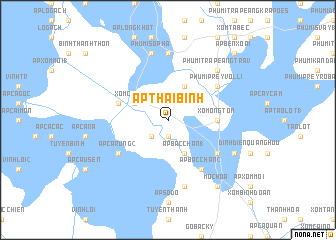
Ấp Thái Bình (Long An, Vietnam)Ấp Thái Bình is a town in the Long An region of Vietnam. An overview map of the region around Ấp Thái Bình is displayed below.
regional and 3d topo map of Ấp Thái Bình, Vietnam ::
Ấp Thái Bình airports ::
The nearest airport is SGN - Ho Chi Minh City Tansonnhat Intl, located 84.1 km east of Ấp Thái Bình.
Other airports nearby include PNH - Phnom-penh Phnom Penh Intl (138.2 km north west), Nearby towns ::
Ấp Nhà Ông (1.9km south) //
Ấp Tuyến Bình (2.6km south west) //
Ấp Bắc Chan (1) (4.1km south east) //
Ấp Binh Châu (1) (4.1km north west) //
Xóm Cả Bàng (4.1km north west) //
Ấp Bên Tràm (4.1km north west) //
Phumĭ Châb Pring (4.1km north east) //
Bình Hiệp (5.5km east) //
Xóm Ông Tớn (5.5km east) //
Ấp Binh Châu (2) (5.8km west) //
Ấp Cá Rưng (2) (6.6km south west) //
Ấp Gò Dưa (6.6km south east) //
Ấp Bắc Chan (2) (6.6km south east) //
Khŭm Thmei (6.6km north east) //
Phumĭ Prey Vôllĭ (6.6km north east) //
Phumĭ Poŭthĭ Kroch (7.4km north) //
Ấp Tuyên Thạnh (7.6km south) //
Phumĭ Sopha (7.6km north) //
Phumĭ Trâpeăng Trav (7.8km north east) //
Ấp Gò Vồ (8.2km south east) //
Mộc Hóa (9.2km south east) //
Ấp Bên Xoài (10.4km north east) //
[all distances 'as the bird flies' and approximate]  Places with similar names to Ấp Thái Bình, Vietnam ::
// Ấp Thái Bình (VN)
// Ấp Thới Bình (VN)
Disclaimer :: Information on this page comes without warranty of any kind |
||
|
Where is Ấp Thái Bình? Elevation and coordinates ::
Latitude (lat): 10°50'0"N Longitude (lon): 105°53'0"E
Elevation (approx.): 3m (map arrows pan, magnifying glasses zoom) |
||
|
Visiting Ấp Thái Bình? Hotel/Accommodation ::
Book a hotel in Ấp Thái Bình Travel Guide ::
Buy a travel guide for Vietnam rental cars ::
car rental offers GPS waypoint ::
download a GPX waypoint (PoI) of Ấp Thái Bình for your GPS receiver
|
||