|
search place name
|
||
Ấp Thạnh Ðiền (Minh Hải, Vietnam)Ấp Thạnh Ðiền is a town in the Minh Hải region of Vietnam. An overview map of the region around Ấp Thạnh Ðiền is displayed below.
regional and 3d topo map of Ấp Thạnh Ðiền, Vietnam ::

Ấp Thạnh Ðiền airports ::
The nearest airport is SGN - Ho Chi Minh City Tansonnhat Intl, located 250.0 km north east of Ấp Thạnh Ðiền.
Nearby towns ::
Ấp Sông Cái (3.5km south east) //
Hòa Thành (3.6km south east) //
Ấp Ba Bèo (3.6km south west) //
Ấp Tân Phong (3.6km east) //
Ấp Hóa Tách (3.9km south east) //
Dinh Ðiền Cống Ðá (4.0km south east) //
Cà Mau (5.2km north) //
Ấp Ông Muộn (5.2km north west) //
Ấp Tân Lập (5.3km south) //
Ấp Kinh Xáng (6.0km south) //
Ấp Nha Phấn (6.1km south west) //
Ấp Rạch Muối (6.1km west) //
Ấp Cỏ Xước (6.5km north west) //
Ấp Mương Ðiều (2) (7.0km south east) //
Ấp Tân Ðức (7.2km west) //
Phong Lạc (7.2km west) //
Ấp Bùng Binh (8.1km east) //
Ấp Ba Vinh (8.4km east) //
Ấp Tắc Thủ (8.8km north west) //
Ấp Bình Phước (1) (8.9km north west) //
Ấp Cái Ngan (9.1km east) //
Ấp Rạch Bần (9.4km north) //
Ấp Tân Ðức (10.2km north east) //
Ấp Tân An (10.3km south west) //
Xóm Lơn (10.6km north east) //
Ấp Khánh Hậu (11.2km north west) //
[all distances 'as the bird flies' and approximate] 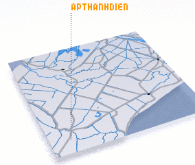 Places with similar names to Ấp Thạnh Ðiền, Vietnam ::
Disclaimer :: Information on this page comes without warranty of any kind |
||
|
Where is Ấp Thạnh Ðiền? Elevation and coordinates ::
Latitude (lat): 9°8'0"N Longitude (lon): 105°8'0"E
Elevation (approx.): 2m (map arrows pan, magnifying glasses zoom) |
||
|
Visiting Ấp Thạnh Ðiền? Hotel/Accommodation ::
Book a hotel in Ấp Thạnh Ðiền Travel Guide ::
Buy a travel guide for Vietnam rental cars ::
car rental offers GPS waypoint ::
download a GPX waypoint (PoI) of Ấp Thạnh Ðiền for your GPS receiver
|
||