|
search place name
|
||
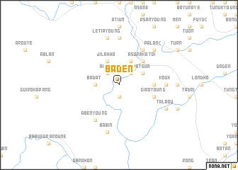
Ba Ðên (Quảng Nam-Ðà Nẵng, Vietnam)Ba Ðên is a town in the Quảng Nam-Ðà Nẵng region of Vietnam. An overview map of the region around Ba Ðên is displayed below.
regional and 3d topo map of Ba Ðên, Vietnam ::
Ba Ðên airports ::
The nearest airport is DAD - Danang Intl, located 66.3 km north east of Ba Ðên.
Other airports nearby include PKZ - Pakse (212.0 km west), Nearby towns ::
Kadap (1.9km south) //
Adial (2.6km north west) //
Ðat Ðơn (2.6km north east) //
Badat (3.6km west) //
Jilahho (4.1km north west) //
A Sơ Ra Kadao (4.1km north east) //
Pa Tsưa (4.0km north east) //
A Sơ Ră Katoi (5.1km north east) //
Giáo (5.3km east) //
Giaô Young (5.7km east) //
Aben Young (6.6km south west) //
A Sơ Young (6.6km north east) //
Atiun Young (7.4km north) //
Kouk (7.1km east) //
Lêtia Dadiou (7.6km north) //
Lêtia Young (7.6km north) //
Babin (7.6km south) //
Pa Lẳn (2) (7.7km north east) //
A Sơ Ră Amo (7.7km north east) //
Talaou (8.0km south east) //
[all distances 'as the bird flies' and approximate]  Places with similar names to Ba Ðên, Vietnam ::
Disclaimer :: Information on this page comes without warranty of any kind |
||
|
Where is Ba Ðên? Elevation and coordinates ::
Latitude (lat): 15°48'0"N Longitude (lon): 107°38'0"E
Elevation (approx.): 848m (map arrows pan, magnifying glasses zoom) |
||
|
Visiting Ba Ðên? Hotel/Accommodation ::
Book a hotel in Ba Ðên Travel Guide ::
Buy a travel guide for Vietnam rental cars ::
car rental offers GPS waypoint ::
download a GPX waypoint (PoI) of Ba Ðên for your GPS receiver
|
||