|
search place name
|
||
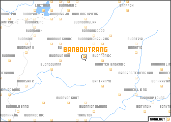
Ban Bou Trang (Ðắc Lắk, Vietnam)Ban Bou Trang is a town in the Ðắc Lắk region of Vietnam. An overview map of the region around Ban Bou Trang is displayed below.
regional and 3d topo map of Ban Bou Trang, Vietnam ::
Ban Bou Trang airports ::
The nearest airport is NHA - Nhatrang, located 101.2 km east of Ban Bou Trang.
Other airports nearby include SGN - Ho Chi Minh City Tansonnhat Intl (241.8 km south west), Nearby towns ::
Buôn Nang (2) (3.6km east) //
Ban Py (4.1km north east) //
Buôn Nang Kralang (4.1km north east) //
Buôn Jie Yuk (4.1km north west) //
Buôn Boun (5.2km north east) //
Buôn Dur Mah (5.4km west) //
Ban Nang Parr (5.8km north) //
Buôn Tchieng Kao (2) (5.7km east) //
Buôn Dung Hma (2) (6.6km north west) //
Ban Tran Yo (6.6km south east) //
Buôn Dong Lap (7.4km north) //
Buôn Dou R'ma (7.5km west) //
Ban Nang Lieng Boc (7.8km north east) //
Buôn Dung Hma (1) (8.1km north west) //
Bon Tiang Wir (10.4km south east) //
[all distances 'as the bird flies' and approximate] 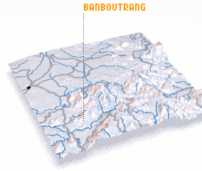 Places with similar names to Ban Bou Trang, Vietnam ::
// Ban Bua Ta Rung (TH)
// Bản Bứu Trong (VN)
Disclaimer :: Information on this page comes without warranty of any kind |
||
|
Where is Ban Bou Trang? Elevation and coordinates ::
Latitude (lat): 12°19'0"N Longitude (lon): 108°16'0"E
Elevation (approx.): 718m (map arrows pan, magnifying glasses zoom) |
||
|
Visiting Ban Bou Trang? Hotel/Accommodation ::
Book a hotel in Ban Bou Trang Travel Guide ::
Buy a travel guide for Vietnam rental cars ::
car rental offers GPS waypoint ::
download a GPX waypoint (PoI) of Ban Bou Trang for your GPS receiver
|
||