|
search place name
|
||
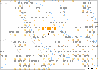
Bản Hào (Sơn La, Vietnam)Bản Hào is a town in the Sơn La region of Vietnam. An overview map of the region around Bản Hào is displayed below.
regional and 3d topo map of Bản Hào, Vietnam ::
Bản Hào airports ::
The nearest airport is LPQ - Luang Prabang Luang Phabang Intl, located 247.9 km south west of Bản Hào.
Nearby towns ::
Pa Ét (1.7km east) //
Bản It Chiêng (1.7km east) //
Bản Huói Nôc (1.7km east) //
Bản Tôm (1.7km west) //
Nậm Ét (1.7km west) //
Bản Lốm (2.5km north east) //
Bản Bôm Phang (2.5km north west) //
Bản Lạng (3.4km east) //
Bản Lầu (4.1km north east) //
Bản Mương (3.9km north west) //
Bản Chiềng Ngam (3.9km south west) //
Bản Xắt (5.1km south east) //
Bản Cốc Phat (5.2km west) //
Bản Bắc (5.2km east) //
Co Ðứa (5.2km east) //
Nong Cạn (5.6km south) //
Bản Cuôi (5.8km south) //
Bản Bo Co (5.5km west) //
Kouei Tam (5.8km north) //
Bản Min (5.8km south) //
Bản Tam (5.8km south) //
Pá Mùng (6.4km north east) //
Bản Huôi Poung (6.4km north west) //
Pá Dôn (6.4km north east) //
Bản Na Cáu (6.5km south east) //
Bản Huội Xất (6.4km south east) //
Bản Bo Ma (6.5km south west) //
Bản Na Pat (6.9km west) //
Bản Na Luc (6.9km west) //
[all distances 'as the bird flies' and approximate] 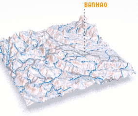 Places with similar names to Bản Hào, Vietnam ::
Disclaimer :: Information on this page comes without warranty of any kind |
||
|
Where is Bản Hào? Elevation and coordinates ::
Latitude (lat): 21°33'0"N Longitude (lon): 103°46'0"E
Elevation (approx.): 508m (map arrows pan, magnifying glasses zoom) |
||
|
Visiting Bản Hào? Hotel/Accommodation ::
Book a hotel in Bản Hào Travel Guide ::
Buy a travel guide for Vietnam rental cars ::
car rental offers GPS waypoint ::
download a GPX waypoint (PoI) of Bản Hào for your GPS receiver
|
||