|
search place name
|
||
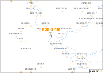
Ban Hloin (Ðắc Lắk, Vietnam)Ban Hloin is a town in the Ðắc Lắk region of Vietnam. An overview map of the region around Ban Hloin is displayed below.
regional and 3d topo map of Ban Hloin, Vietnam ::
Ban Hloin airports ::
The nearest airport is NHA - Nhatrang, located 121.8 km south east of Ban Hloin.
Nearby towns ::
Ban Huy (1.9km south) //
Phước An (2.6km south east) //
Ban Bat (2.6km north west) //
Ban Bliep (2.6km north west) //
Phú Túc (3.6km east) //
Ban Ma Nhiu (1) (4.1km south east) //
Ban Ma Nga (4.1km south east) //
Ban M'rok (4.1km north west) //
Ban Duk (4.1km north west) //
Hnguom (4.1km north west) //
Ba Ma Dang (5.8km south) //
Ban Oi Dji (1) (5.7km east) //
Ban Bong Black (6.6km south east) //
Ban Ba Mla (6.6km south east) //
Ban Blang (7.8km south east) //
Ban Chai (8.1km north west) //
Ban Oy Lao (8.2km north west) //
Ban Oy Thua (1) (9.2km north west) //
Ban Huiet (9.2km south east) //
[all distances 'as the bird flies' and approximate]  Places with similar names to Ban Hloin, Vietnam ::
Disclaimer :: Information on this page comes without warranty of any kind |
||
|
Where is Ban Hloin? Elevation and coordinates ::
Latitude (lat): 13°12'0"N Longitude (lon): 108°40'0"E
Elevation (approx.): 119m (map arrows pan, magnifying glasses zoom) |
||
|
Visiting Ban Hloin? Hotel/Accommodation ::
Book a hotel in Ban Hloin Travel Guide ::
Buy a travel guide for Vietnam rental cars ::
car rental offers GPS waypoint ::
download a GPX waypoint (PoI) of Ban Hloin for your GPS receiver
|
||