|
search place name
|
||
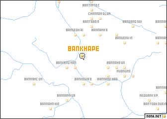
Bản Kha Pể (Lai Châu, Vietnam)Bản Kha Pể is a town in the Lai Châu region of Vietnam. An overview map of the region around Bản Kha Pể is displayed below.
regional and 3d topo map of Bản Kha Pể, Vietnam ::
Nearby towns ::
Bản Nằm Lò (2.5km south west) //
Bản Giào (2.5km south west) //
Bản Kẻng Mắn (3.9km south west) //
Bản Pá Hà (5.6km north) //
Bản Giào (5.6km south) //
Bản Ké Giào (5.6km south) //
Bản Pá Hà Seo Hai (5.6km north) //
Bản Nằm Tô (5.6km north) //
Bản Seo Hai (5.8km north) //
Bản Cang Hao (5.5km east) //
Bản Nằm Hon (5.8km south) //
Bản Nằm Khao (6.3km south east) //
Bản Nằm Hà (6.5km north east) //
Bản Ta Bon (7.6km north) //
Bản Nằm Sun (7.1km east) //
Bản Nằm Khao (7.6km south east) //
Bản Ðen Ðin (8.8km north east) //
[all distances 'as the bird flies' and approximate]  Places with similar names to Bản Kha Pể, Vietnam ::
// Ban Khao Po (TH)
// Ban Khi Poe (TH)
// Ban Khup (TH)
// Ban Khap (LA)
// Ban Khap (LA)
// Ban Khopuay (LA)
Disclaimer :: Information on this page comes without warranty of any kind |
||
|
Where is Bản Kha Pể? Elevation and coordinates ::
Latitude (lat): 22°15'0"N Longitude (lon): 102°50'0"E
Elevation (approx.): 1073m (map arrows pan, magnifying glasses zoom) |
||
|
Visiting Bản Kha Pể? Hotel/Accommodation ::
Book a hotel in Bản Kha Pể Travel Guide ::
Buy a travel guide for Vietnam rental cars ::
car rental offers GPS waypoint ::
download a GPX waypoint (PoI) of Bản Kha Pể for your GPS receiver
|
||