|
search place name
|
||
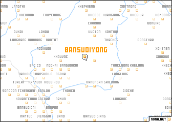
Bản Suối Yong (Vietnam)Bản Suối Yong is a town in Vietnam. An overview map of the region around Bản Suối Yong is displayed below.
regional and 3d topo map of Bản Suối Yong, Vietnam ::
Bản Suối Yong airports ::
The nearest airport is HAN - Hanoi Noibai Intl, located 138.9 km south east of Bản Suối Yong.
Nearby towns ::
Ngòi Hai (1.7km east) //
Bản Suối Kim (3.9km south west) //
Bản Suối Chang (5.1km south west) //
Càu Tao (5.6km south) //
Khâu Vác (5.2km west) //
Khê Sung (5.5km east) //
Bản Sôi Peng (5.5km west) //
Vực Tổn (5.8km north) //
Bản Bam (5.8km south) //
Vầng Ngàn (5.8km south) //
Ngo Ha (6.4km south west) //
Thách Cá (6.4km north east) //
Ngó Hai (7.1km west) //
Cánh Tiên (7.1km east) //
Thác Lương (7.1km east) //
Chà Khui (7.6km north) //
Xóm Thip (7.6km north east) //
Sài Lương (7.6km south east) //
Kouei Fong (7.6km south west) //
Thầm Có (8.2km south west) //
Bản Tát (7.8km north west) //
Làng Lũng (7.8km south east) //
Kouei Hou (8.9km south west) //
Bản Suối Ma (8.9km south west) //
[all distances 'as the bird flies' and approximate]  Places with similar names to Bản Suối Yong, Vietnam ::
Disclaimer :: Information on this page comes without warranty of any kind |
||
|
Where is Bản Suối Yong? Elevation and coordinates ::
Latitude (lat): 21°44'0"N Longitude (lon): 104°35'0"E
Elevation (approx.): 1178m (map arrows pan, magnifying glasses zoom) |
||
|
Visiting Bản Suối Yong? Hotel/Accommodation ::
Book a hotel in Bản Suối Yong Travel Guide ::
Buy a travel guide for Vietnam rental cars ::
car rental offers GPS waypoint ::
download a GPX waypoint (PoI) of Bản Suối Yong for your GPS receiver
|
||