|
search place name
|
||
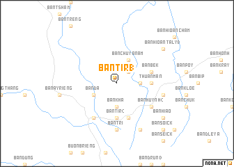
Ban Tir (1) (Ðắc Lắk, Vietnam)Ban Tir (1) is a town in the Ðắc Lắk region of Vietnam. An overview map of the region around Ban Tir (1) is displayed below.
regional and 3d topo map of Ban Tir (1), Vietnam ::
Ban Tir (1) airports ::
The nearest airport is NHA - Nhatrang, located 152.5 km south east of Ban Tir (1).
Nearby towns ::
Ban Krang (2.6km north east) //
Ban Hoaï (2) (3.6km east) //
Ban Khá (3.7km south) //
Ban Da (4.1km south west) //
Ban Chư Ya Nam (4.1km north east) //
Thuần Mẫn (5.4km east) //
Ban Tir (2) (5.6km south) //
Ban Bek (5.7km east) //
Ban Draé (5.8km south) //
Ban Huynh (2) (6.6km south east) //
Ban Blech (6.6km south west) //
Ban Tri (7.4km south) //
Ban Huynh (3) (7.5km east) //
Ban Cho Ah (8.2km south east) //
Ban Hioan Taly (1) (9.1km north east) //
Ban Hiao (9.1km south east) //
Ban Soick (10.3km south east) //
[all distances 'as the bird flies' and approximate]  Places with similar names to Ban Tir (1), Vietnam ::
// Bantry Bay (ZA)
// Bandarbi (SD)
// Bendirba (NG)
// Bantar 1 (ID)
// Buôn Tur (1) (VN)
// Bønderby (DK)
// Bondarby (FI)
Disclaimer :: Information on this page comes without warranty of any kind |
||
|
Where is Ban Tir (1)? Elevation and coordinates ::
Latitude (lat): 13°15'0"N Longitude (lon): 108°15'0"E
Elevation (approx.): 582m (map arrows pan, magnifying glasses zoom) |
||
|
Visiting Ban Tir (1)? Hotel/Accommodation ::
Book a hotel in Ban Tir (1) Travel Guide ::
Buy a travel guide for Vietnam rental cars ::
car rental offers GPS waypoint ::
download a GPX waypoint (PoI) of Ban Tir (1) for your GPS receiver
|
||