|
search place name
|
||
Bản Xà (1) (Sơn La, Vietnam)Bản Xà (1) is a town in the Sơn La region of Vietnam. An overview map of the region around Bản Xà (1) is displayed below.
regional and 3d topo map of Bản Xà (1), Vietnam ::

Bản Xà (1) airports ::
The nearest airport is HAN - Hanoi Noibai Intl, located 135.2 km east of Bản Xà (1).
Nearby towns ::
Bản Xa (1.9km south) //
To Lang (3.5km west) //
Chiêng Ve (3.5km west) //
So Lườn (3.7km north) //
Bản Xà (2) (3.7km south) //
Bản Vật (5.8km north) //
Mộc Thượng (7.6km north) //
Bản Àng (7.6km north) //
Bản Giúp (7.2km east) //
Tô Bang (7.2km west) //
Bản A La (7.2km west) //
Làng Môn (9.1km north east) //
Pien Kaye (8.9km south west) //
[all distances 'as the bird flies' and approximate] 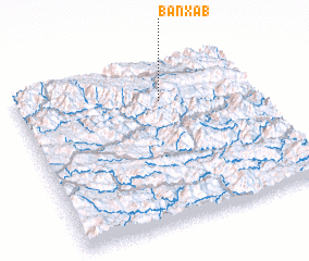 Places with similar names to Bản Xà (1), Vietnam ::
// Benque Ceiba (BZ)
// Ban Kai Sao (1) (TH)
// Ban Ko Saba (TH)
// Ban Ko Saba (TH)
// Ban Ko Saba (TH)
// Ban Ko Sua (1) (TH)
// Bunga Sabua (NG)
// Ban Naxay (1) (LA)
// Ban Xao (1) (LA)
// Ban Xébo (LA)
Disclaimer :: Information on this page comes without warranty of any kind |
||
|
Where is Bản Xà (1)? Elevation and coordinates ::
Latitude (lat): 20°46'0"N Longitude (lon): 104°36'0"E
Elevation (approx.): 772m (map arrows pan, magnifying glasses zoom) |
||
|
Visiting Bản Xà (1)? Hotel/Accommodation ::
Book a hotel in Bản Xà (1) Travel Guide ::
Buy a travel guide for Vietnam rental cars ::
car rental offers GPS waypoint ::
download a GPX waypoint (PoI) of Bản Xà (1) for your GPS receiver
|
||