|
search place name
|
||
Beng Mương (Vietnam)Beng Mương is a town in Vietnam. An overview map of the region around Beng Mương is displayed below.
regional and 3d topo map of Beng Mương, Vietnam ::

Beng Mương airports ::
The nearest airport is HAN - Hanoi Noibai Intl, located 116.8 km east of Beng Mương.
Nearby towns ::
Làng Khê Ðịa (3.9km north east) //
Ba Khè (5.1km north west) //
Khé Long (5.2km east) //
Ngon Fa (5.5km west) //
Làng Mỹ (2) (6.4km north east) //
Thac Vác (6.4km north west) //
Làng Mỹ (1) (7.1km east) //
Khê Xung (7.1km east) //
Bản Thẳm (8.9km south east) //
Làng Biểu (9.0km south east) //
Khon Dam (9.0km north east) //
Thượng Bắng La (10.1km south east) //
Ngòi Lao (10.1km south west) //
Nà Chạm (10.1km north west) //
Cốc Bang (10.1km north west) //
[all distances 'as the bird flies' and approximate] 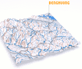 Places with similar names to Beng Mương, Vietnam ::
// Bang Mun Nak (TH)
// Ban Kiu Muang (TH)
// Ban Kiu Muang (TH)
// Ban Kui Mang (TH)
// Ban Ku Mung (TH)
// Ban Ku Mung (TH)
// Ban Nga Maeng (TH)
// Ban Kèomèng (LA)
// Ban Kioumang (LA)
// Ban Kioumouang (LA)
Disclaimer :: Information on this page comes without warranty of any kind |
||
|
Where is Beng Mương? Elevation and coordinates ::
Latitude (lat): 21°29'0"N Longitude (lon): 104°43'0"E
Elevation (approx.): 251m (map arrows pan, magnifying glasses zoom) |
||
|
Visiting Beng Mương? Hotel/Accommodation ::
Book a hotel in Beng Mương Travel Guide ::
Buy a travel guide for Vietnam rental cars ::
car rental offers GPS waypoint ::
download a GPX waypoint (PoI) of Beng Mương for your GPS receiver
|
||