|
search place name
|
||
Buôn Ea Niaêh (Ðắc Lắk, Vietnam)Buôn Ea Niaêh is a town in the Ðắc Lắk region of Vietnam. An overview map of the region around Buôn Ea Niaêh is displayed below.
regional and 3d topo map of Buôn Ea Niaêh, Vietnam ::

Buôn Ea Niaêh airports ::
The nearest airport is NHA - Nhatrang, located 118.2 km south east of Buôn Ea Niaêh.
Other airports nearby include SGN - Ho Chi Minh City Tansonnhat Intl (269.1 km south west), Nearby towns ::
Buôn Briêng (1.9km north) //
Buôn Pu Huèh (1.9km south) //
Buôn Pok (2.6km north east) //
Buôn Krèh (1) (2.6km south east) //
Buôn Kang (3.7km south) //
Buôn Ea Pur (5.2km south west) //
Nông Trại (5.4km east) //
Ðịa Ðiểm Ea Kniach (5.6km south) //
Buôn Yĕ (2) (5.8km north) //
Buôn Yĕ (1) (5.8km north) //
Buôn Jung (6.6km south east) //
Buôn Chur Tara (7.2km west) //
Buôn Aring (7.6km north) //
Buôn Krum (8.2km north east) //
Buôn Krôa (3) (8.1km north west) //
Buôn Pu Huê (8.2km south west) //
Buôn Cuôr Dang (8.2km north west) //
Buôn Krôa (2) (9.1km north west) //
Buôn Jung (9.2km south west) //
[all distances 'as the bird flies' and approximate] 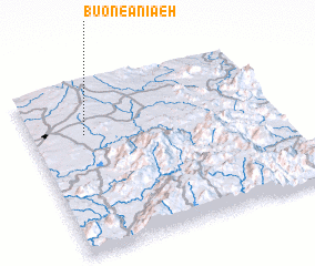 Places with similar names to Buôn Ea Niaêh, Vietnam ::
Disclaimer :: Information on this page comes without warranty of any kind |
||
|
Where is Buôn Ea Niaêh? Elevation and coordinates ::
Latitude (lat): 12°42'0"N Longitude (lon): 108°13'0"E
Elevation (approx.): 576m (map arrows pan, magnifying glasses zoom) |
||
|
Visiting Buôn Ea Niaêh? Hotel/Accommodation ::
Book a hotel in Buôn Ea Niaêh Travel Guide ::
Buy a travel guide for Vietnam rental cars ::
car rental offers GPS waypoint ::
download a GPX waypoint (PoI) of Buôn Ea Niaêh for your GPS receiver
|
||