|
search place name
|
||
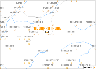
Buôn Pro Trong (Lâm Ðồng, Vietnam)Buôn Pro Trong is a town in the Lâm Ðồng region of Vietnam. An overview map of the region around Buôn Pro Trong is displayed below.
regional and 3d topo map of Buôn Pro Trong, Vietnam ::
Buôn Pro Trong airports ::
The nearest airport is NHA - Nhatrang, located 92.5 km north east of Buôn Pro Trong.
Other airports nearby include SGN - Ho Chi Minh City Tansonnhat Intl (227.4 km south west), Nearby towns ::
Buôn Proyou (0.0km north) //
Buôn Prongo (1.8km east) //
Buôn Karang Co (2.6km north west) //
Buôn Kai (3.6km west) //
Buôn Kill Ka Ploung (4.1km north east) //
Thanh Hòa (5.2km north west) //
Kadê Mtôt (5.2km north west) //
Kadeune (1) (5.4km west) //
Brelah (5.4km west) //
M”lon (1) (6.6km north west) //
Lac Nghĩa (6.6km north west) //
Tarklette (7.5km west) //
Tho Méria (7.5km west) //
R”lom (7.5km west) //
Xieng Tiaro (7.6km south) //
Kadô (7.6km north) //
Klot (8.2km south west) //
Kàram (8.2km south west) //
Pho Hou Hou (10.4km south east) //
[all distances 'as the bird flies' and approximate] 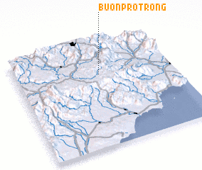 Places with similar names to Buôn Pro Trong, Vietnam :: Disclaimer :: Information on this page comes without warranty of any kind |
||
|
Where is Buôn Pro Trong? Elevation and coordinates ::
Latitude (lat): 11°42'0"N Longitude (lon): 108°32'0"E
Elevation (approx.): 1038m (map arrows pan, magnifying glasses zoom) |
||
|
Visiting Buôn Pro Trong? Hotel/Accommodation ::
Book a hotel in Buôn Pro Trong Travel Guide ::
Buy a travel guide for Vietnam rental cars ::
car rental offers GPS waypoint ::
download a GPX waypoint (PoI) of Buôn Pro Trong for your GPS receiver
|
||