|
search place name
|
||
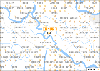
Cẩm Văn (Hải Phòng, Vietnam)Cẩm Văn is a town in the Hải Phòng region of Vietnam. An overview map of the region around Cẩm Văn is displayed below.
regional and 3d topo map of Cẩm Văn, Vietnam ::
Cẩm Văn airports ::
The nearest airport is HAN - Hanoi Noibai Intl, located 88.7 km north west of Cẩm Văn.
Other airports nearby include NNG - Nanning Wuxu (262.4 km north east), Nearby towns ::
Cai Tiên (1.7km west) //
Dong Thôn (1.7km east) //
Cau Trung (2.5km north west) //
Làng Liên (2.5km south west) //
Ðông Tân (2.5km south east) //
Quang Khải (3.5km north) //
Lâm Cao (3.7km south) //
Dại Trang (4.1km north west) //
Dai Cong (4.1km south west) //
Thương Thôn (4.1km south west) //
Câm La (4.1km south east) //
An Luận (3.9km north east) //
Thôn Ngoai (3.9km north east) //
Dại Hoang (4.5km east) //
Hòn Chu (5.1km north east) //
Chi Lai (5.1km north east) //
Khuc Giản (5.1km north east) //
Kinh Khê (5.6km south) //
Mậu Công (5.5km west) //
Tất Cầu (5.8km south) //
Tỉnh Thủy (5.8km north) //
Xuân Sơn (5.5km east) //
Tiện Hội (5.5km east) //
Ly Câu (5.5km east) //
Lien Dinh (6.4km north) //
Ha Chương (6.4km north west) //
Nghía Trang (6.6km north west) //
An Qui (6.6km south west) //
Nội Thắng (6.6km south west) //
[all distances 'as the bird flies' and approximate]  Places with similar names to Cẩm Văn, Vietnam ::
Disclaimer :: Information on this page comes without warranty of any kind |
||
|
Where is Cẩm Văn? Elevation and coordinates ::
Latitude (lat): 20°48'0"N Longitude (lon): 106°32'0"E
Elevation (approx.): 5m (map arrows pan, magnifying glasses zoom) |
||
|
Visiting Cẩm Văn? Hotel/Accommodation ::
Book a hotel in Cẩm Văn Travel Guide ::
Buy a travel guide for Vietnam rental cars ::
car rental offers GPS waypoint ::
download a GPX waypoint (PoI) of Cẩm Văn for your GPS receiver
|
||