|
search place name
|
||
Daden (Quảng Nam-Ðà Nẵng, Vietnam)Daden is a town in the Quảng Nam-Ðà Nẵng region of Vietnam. An overview map of the region around Daden is displayed below.
regional and 3d topo map of Daden, Vietnam ::

Daden airports ::
The nearest airport is DAD - Danang Intl, located 51.2 km north east of Daden.
Nearby towns ::
Londho (4.0km south west) //
Daluia (4.0km south west) //
Tung Tang (4.1km south east) //
Gap (6.5km north west) //
Tadri (6.5km south west) //
Tadlòi (6.5km south west) //
Hiên Bồn (6.6km north east) //
Dạt Tâm (2) (6.6km south east) //
Hòa Hiệp (1) (6.5km south east) //
Trưng Hiệp (1) (7.1km east) //
Hagiang (7.4km west) //
Bôn Duối (7.6km north) //
Tuôn (7.7km north west) //
Mỹ Hiệp (2) (7.7km south east) //
Mỹ Hiệp (3) (7.7km south east) //
Tuân (8.0km north west) //
Pa Lẳn (1) (8.0km north west) //
Fu Yu (2) (8.2km north west) //
Bên Hiên Pi Karung (8.2km north east) //
Mỹ Hiệp (4) (8.2km south east) //
Lai (9.0km south west) //
Fu Yu (1) (9.1km north west) //
Hiên Wơ (9.1km north east) //
Mỹ Hiệp (9.1km south east) //
Dai Son (9.1km south east) //
Men (10.3km north west) //
Ðông Cham (1) (10.3km north east) //
[all distances 'as the bird flies' and approximate] 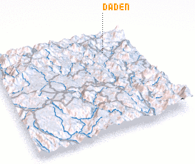 Places with similar names to Daden, Vietnam ::
Disclaimer :: Information on this page comes without warranty of any kind |
||
|
Where is Daden? Elevation and coordinates ::
Latitude (lat): 15°49'0"N Longitude (lon): 107°47'0"E
Elevation (approx.): 132m (map arrows pan, magnifying glasses zoom) |
||
|
Visiting Daden? Hotel/Accommodation ::
Book a hotel in Daden Travel Guide ::
Buy a travel guide for Vietnam rental cars ::
car rental offers GPS waypoint ::
download a GPX waypoint (PoI) of Daden for your GPS receiver
|
||