|
search place name
|
||
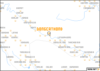
Ðông Ca Thồn (1) (Vietnam)Ðông Ca Thồn (1) is a town in Vietnam. An overview map of the region around Ðông Ca Thồn (1) is displayed below.
regional and 3d topo map of Ðông Ca Thồn (1), Vietnam ::
Ðông Ca Thồn (1) airports ::
The nearest airport is ZVK - Savannakhet, located 201.1 km south west of Ðông Ca Thồn (1).
Other airports nearby include SNO - Sakon Nakhon (217.7 km west), Nearby towns ::
Dồng Cao Thôn (0.0km north) //
Quảng Hóa Phường (1.8km west) //
Ðồng Văn Phường (1.9km south) //
Tâm Ðồng Phường (1.9km south) //
Tâm Ða Phường (2.6km south east) //
Thượng Phong Trang (3.5km west) //
Tân Ninh Phường (4.0km north west) //
Xóm Lạc (4.0km north west) //
Xóm Dùi (4.0km north west) //
Xuân Canh Phường (4.0km south east) //
Ðồng Bang Phường (5.1km south east) //
Ðồng Lạc Xóm (5.1km south east) //
Kiều Mộc Phường (5.1km south east) //
Xóm Trảy (5.6km west) //
Ðại Hòa Phường (5.6km east) //
Lê Tửu Phường (5.6km east) //
Ðồng Giang Phường (6.5km south east) //
Hà Sơn Trang (7.7km south east) //
Khe Trừng Xã (8.0km north west) //
Kim Lũ Xã (9.0km north west) //
[all distances 'as the bird flies' and approximate] 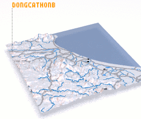 Places with similar names to Ðông Ca Thồn (1), Vietnam :: Disclaimer :: Information on this page comes without warranty of any kind |
||
|
Where is Ðông Ca Thồn (1)? Elevation and coordinates ::
Latitude (lat): 17°54'0"N Longitude (lon): 106°2'0"E
Elevation (approx.): 20m (map arrows pan, magnifying glasses zoom) |
||
|
Visiting Ðông Ca Thồn (1)? Hotel/Accommodation ::
Book a hotel in Ðông Ca Thồn (1) Travel Guide ::
Buy a travel guide for Vietnam rental cars ::
car rental offers GPS waypoint ::
download a GPX waypoint (PoI) of Ðông Ca Thồn (1) for your GPS receiver
|
||