|
search place name
|
||
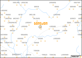
Dong Jon (Bắc Thái, Vietnam)Dong Jon is a town in the Bắc Thái region of Vietnam. An overview map of the region around Dong Jon is displayed below.
regional and 3d topo map of Dong Jon, Vietnam ::
Dong Jon airports ::
The nearest airport is HAN - Hanoi Noibai Intl, located 56.0 km south of Dong Jon.
Nearby towns ::
La Moi (0.0km north) //
Con Vack (0.0km north) //
Suam Son (1.9km north) //
Dong Hon (3.4km east) //
Xa Loung (4.1km north west) //
Khuôi Lương (5.1km south west) //
Ve Don (5.6km south) //
Làng Hai (5.2km east) //
Làng Hít (5.5km west) //
Phổ Lý (5.8km south) //
Cuc Duong (6.5km north east) //
Bac Lao (6.5km north west) //
Làng Moi (6.9km west) //
Nen Van (7.1km east) //
Na Hua (7.6km south) //
Coc Duong (7.6km north east) //
Ke Mon (8.2km south west) //
Na Duong (7.8km south west) //
La Danh (7.8km south west) //
La Ton (7.8km south west) //
Làng Nho (8.9km north east) //
Làng Dan (8.9km south east) //
Tam Tài (10.1km south west) //
Làng Lam (10.1km south west) //
[all distances 'as the bird flies' and approximate] 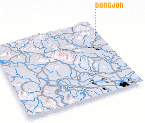 Places with similar names to Dong Jon, Vietnam ::
Disclaimer :: Information on this page comes without warranty of any kind |
||
|
Where is Dong Jon? Elevation and coordinates ::
Latitude (lat): 21°43'0"N Longitude (lon): 105°55'0"E
Elevation (approx.): 77m (map arrows pan, magnifying glasses zoom) |
||
|
Visiting Dong Jon? Hotel/Accommodation ::
Book a hotel in Dong Jon Travel Guide ::
Buy a travel guide for Vietnam rental cars ::
car rental offers GPS waypoint ::
download a GPX waypoint (PoI) of Dong Jon for your GPS receiver
|
||