|
search place name
|
||
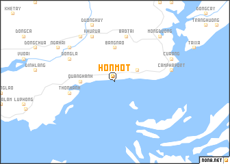
Hòn Một (Quảng Ninh, Vietnam)Hòn Một is a town in the Quảng Ninh region of Vietnam. An overview map of the region around Hòn Một is displayed below.
regional and 3d topo map of Hòn Một, Vietnam ::
Hòn Một airports ::
The nearest airport is HAN - Hanoi Noibai Intl, located 155.3 km west of Hòn Một.
Other airports nearby include NNG - Nanning Wuxu (200.4 km north east), Nearby towns ::
Cẩm Phả Mines (2.5km north east) //
Cẩm Phả (3.9km north east) //
Quang Hanh (5.2km west) //
Bang Nao (5.6km north) //
Thôn Hanh (7.2km west) //
Bao Tai (7.6km north) //
Dồng La (7.9km north west) //
Khu Rua (8.2km north west) //
Huy Ðộng (8.9km north west) //
Gôc Ðon (9.0km north west) //
Mông Dương (10.1km north east) //
[all distances 'as the bird flies' and approximate] 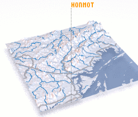 Places with similar names to Hòn Một, Vietnam ::
Disclaimer :: Information on this page comes without warranty of any kind |
||
|
Where is Hòn Một? Elevation and coordinates ::
Latitude (lat): 21°0'0"N Longitude (lon): 107°17'0"E
(map arrows pan, magnifying glasses zoom) |
||
|
Visiting Hòn Một? Hotel/Accommodation ::
Book a hotel in Hòn Một Travel Guide ::
Buy a travel guide for Vietnam rental cars ::
car rental offers GPS waypoint ::
download a GPX waypoint (PoI) of Hòn Một for your GPS receiver
|
||