|
search place name
|
||
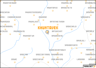
Khum Tavek (Sông Bé, Vietnam)Khum Tavek is a town in the Sông Bé region of Vietnam. An overview map of the region around Khum Tavek is displayed below.
regional and 3d topo map of Khum Tavek, Vietnam ::
Khum Tavek airports ::
The nearest airport is SGN - Ho Chi Minh City Tansonnhat Intl, located 101.7 km south of Khum Tavek.
Other airports nearby include PNH - Phnom-penh Phnom Penh Intl (176.1 km west), Nearby towns ::
Ấp Tuk Chât (3.6km east) //
Ấp Soai Kong (4.1km south east) //
Ấp Ta Thiêt Krom (5.2km north east) //
Phum Por (5.8km north) //
Phumĭ Lvéa (6.6km north west) //
Phum Chéam Pdau (6.6km north west) //
Phumĭ Satum (7.5km west) //
Phum Cheâm Thoum (8.3km south east) //
Phumĭ Stœ̆ng Srei (9.2km north west) //
[all distances 'as the bird flies' and approximate]  Places with similar names to Khum Tavek, Vietnam ::
// Khomutovka (RU)
// Khomutovka (RU)
// Khomutovka (RU)
// Khomutovka (RU)
// Khomutovka (RU)
// Khomutovka (RU)
// Khomutovka (RU)
// Khomutovka (BY)
Disclaimer :: Information on this page comes without warranty of any kind |
||
|
Where is Khum Tavek? Elevation and coordinates ::
Latitude (lat): 11°43'0"N Longitude (lon): 106°27'0"E
Elevation (approx.): 79m (map arrows pan, magnifying glasses zoom) |
||
|
Visiting Khum Tavek? Hotel/Accommodation ::
Book a hotel in Khum Tavek Travel Guide ::
Buy a travel guide for Vietnam rental cars ::
car rental offers GPS waypoint ::
download a GPX waypoint (PoI) of Khum Tavek for your GPS receiver
|
||