|
search place name
|
||
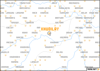
Khuổi Lầy (Cao Bằng, Vietnam)Khuổi Lầy is a town in the Cao Bằng region of Vietnam. An overview map of the region around Khuổi Lầy is displayed below.
regional and 3d topo map of Khuổi Lầy, Vietnam ::
Khuổi Lầy airports ::
The nearest airport is HAN - Hanoi Noibai Intl, located 158.2 km south of Khuổi Lầy.
Nearby towns ::
Nà Chia (2.5km north east) //
Kouei Dao (2.5km south west) //
Nà Noi (3.9km north west) //
Chỏng Hinh (4.1km north east) //
Khuôi Chò (4.1km south west) //
Khuôi Min (4.1km south east) //
Khuổi Lai (5.0km north east) //
Sóc Toan (5.0km north east) //
Na Ðầu (5.1km west) //
Kouôi Pet (5.6km south) //
Khuổi Phay (5.5km west) //
Vò Chang (5.5km east) //
Bản Tuấn (6.5km north east) //
Nà Kep (6.8km east) //
Khôn Côc (7.6km north) //
Tom Penh (7.8km north west) //
Làng Khào (8.2km north west) //
Bốc Thượng (8.2km south east) //
Na Linh (8.2km south east) //
Xuân Lĩnh (9.0km north east) //
Lang Ỉn Tảu (9.0km north west) //
Nà Ca (9.0km north west) //
Bản Chang (3) (8.8km north west) //
Lin Luồng (10.1km north east) //
[all distances 'as the bird flies' and approximate] 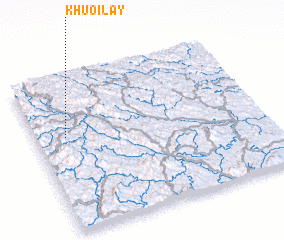 Places with similar names to Khuổi Lầy, Vietnam ::
Disclaimer :: Information on this page comes without warranty of any kind |
||
|
Where is Khuổi Lầy? Elevation and coordinates ::
Latitude (lat): 22°37'0"N Longitude (lon): 106°8'0"E
Elevation (approx.): 381m (map arrows pan, magnifying glasses zoom) |
||
|
Visiting Khuổi Lầy? Hotel/Accommodation ::
Book a hotel in Khuổi Lầy Travel Guide ::
Buy a travel guide for Vietnam rental cars ::
car rental offers GPS waypoint ::
download a GPX waypoint (PoI) of Khuổi Lầy for your GPS receiver
|
||