|
search place name
|
||
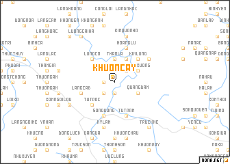
Khuôn Cẩy (Vietnam)Khuôn Cẩy is a town in Vietnam. An overview map of the region around Khuôn Cẩy is displayed below.
regional and 3d topo map of Khuôn Cẩy, Vietnam ::
Khuôn Cẩy airports ::
The nearest airport is HAN - Hanoi Noibai Intl, located 71.2 km south east of Khuôn Cẩy.
Nearby towns ::
Khang Lực (1.7km west) //
Phượng Liễn (1.9km south) //
Lung Bong (2.5km north east) //
Ðong Hoan (2.5km south west) //
Than La (3.7km north) //
Kiên Trận (4.1km north east) //
Thôn Xương (3.9km north east) //
Quảng Ðàm (3.9km south east) //
Kim Lung (5.1km north east) //
Tú Trạc (5.1km south west) //
Lung Co (5.1km north west) //
Hoàng Lũ (5.8km north) //
Hạ Yên (5.8km north) //
Tử Trầm (5.8km south) //
Bắc Lũng (5.8km south) //
Làng Ca (1) (5.5km west) //
Sơn Dương (5.8km south) //
Khôi Cháo (6.4km north east) //
Kim Quan Hạ (7.6km north) //
Kỳ Lâm (7.6km south) //
Dà Năng (7.8km south west) //
Lương Cải Hạ (9.0km north west) //
Trúc Khê (9.0km south east) //
Khon Chu (10.1km north west) //
[all distances 'as the bird flies' and approximate]  Places with similar names to Khuôn Cẩy, Vietnam ::
Disclaimer :: Information on this page comes without warranty of any kind |
||
|
Where is Khuôn Cẩy? Elevation and coordinates ::
Latitude (lat): 21°45'0"N Longitude (lon): 105°25'0"E
Elevation (approx.): 75m (map arrows pan, magnifying glasses zoom) |
||
|
Visiting Khuôn Cẩy? Hotel/Accommodation ::
Book a hotel in Khuôn Cẩy Travel Guide ::
Buy a travel guide for Vietnam rental cars ::
car rental offers GPS waypoint ::
download a GPX waypoint (PoI) of Khuôn Cẩy for your GPS receiver
|
||