|
search place name
|
||
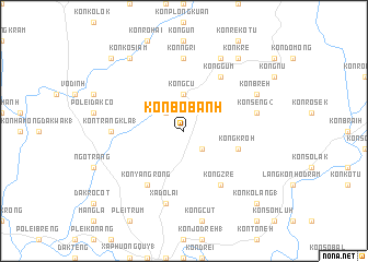
Kon Bơbanh (Vietnam)Kon Bơbanh is a town in Vietnam. An overview map of the region around Kon Bơbanh is displayed below.
regional and 3d topo map of Kon Bơbanh, Vietnam ::
Kon Bơbanh airports ::
The nearest airport is DAD - Danang Intl, located 175.4 km north of Kon Bơbanh.
Nearby towns ::
Kong Ngu (2.6km north west) //
Kong Gua (2.6km south east) //
Kong Cu (3.7km north) //
Kong Kroh (5.7km east) //
Kon Yang Rong (6.6km south west) //
Kong Zré (6.6km south east) //
Kong Gum (6.6km north east) //
Kon Trang Kla (1) (7.2km west) //
Kon Ngri (7.4km north) //
Kong Tri (7.4km north) //
Xã Do Lai (7.6km south) //
Kon Seng (2) (7.4km east) //
Kon Kokơtu (8.2km north east) //
Kon Breh (8.1km north east) //
Kon Kơ Siam (9.2km north west) //
Kon Kré (9.2km north east) //
Kon Pah (9.2km north east) //
Kon Dak Dem (10.3km north west) //
Kon Kơlang (1) (10.3km south east) //
[all distances 'as the bird flies' and approximate] 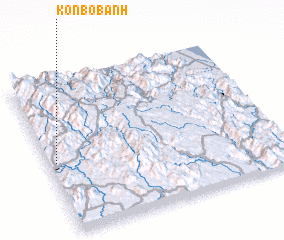 Places with similar names to Kon Bơbanh, Vietnam :: Disclaimer :: Information on this page comes without warranty of any kind |
||
|
Where is Kon Bơbanh? Elevation and coordinates ::
Latitude (lat): 14°28'0"N Longitude (lon): 108°2'0"E
Elevation (approx.): 650m (map arrows pan, magnifying glasses zoom) |
||
|
Visiting Kon Bơbanh? Hotel/Accommodation ::
Book a hotel in Kon Bơbanh Travel Guide ::
Buy a travel guide for Vietnam rental cars ::
car rental offers GPS waypoint ::
download a GPX waypoint (PoI) of Kon Bơbanh for your GPS receiver
|
||