|
search place name
|
||
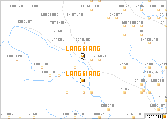
Làng Giáng (Thanh Hóa, Vietnam)Làng Giáng is a town in the Thanh Hóa region of Vietnam. An overview map of the region around Làng Giáng is displayed below.
regional and 3d topo map of Làng Giáng, Vietnam ::
Làng Giáng airports ::
The nearest airport is HAN - Hanoi Noibai Intl, located 132.0 km north east of Làng Giáng.
Nearby towns ::
Hương Lang Chánh (0.5km north west) //
Trung Lương (1.7km east) //
Làng Cười (1.9km north) //
Ðức Ang (2.5km south west) //
Làng Vât (3.5km east) //
Tự Lạc (3.7km north) //
Ðồng Lạc (3.7km north) //
Trí Nang (4.1km south west) //
Ðầu Bè (5.1km south west) //
Làng A (5.1km south east) //
Ngọc Khê (5.1km south east) //
Làng Giáng (5.6km south) //
Làng Cẳy (6.4km south west) //
Văn Cảu (6.4km north west) //
Yên Thổ (7.4km south) //
Làng Tô (7.6km south) //
Làng Mo (7.6km north west) //
Làng Chiêng Nang (8.2km south west) //
Làng Cát (7.9km south west) //
Tuy Thịnh (9.1km north west) //
[all distances 'as the bird flies' and approximate] 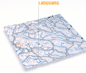 Places with similar names to Làng Giáng, Vietnam ::
Disclaimer :: Information on this page comes without warranty of any kind |
||
|
Where is Làng Giáng? Elevation and coordinates ::
Latitude (lat): 20°9'0"N Longitude (lon): 105°15'0"E
Elevation (approx.): 72m (map arrows pan, magnifying glasses zoom) |
||
|
Visiting Làng Giáng? Hotel/Accommodation ::
Book a hotel in Làng Giáng Travel Guide ::
Buy a travel guide for Vietnam rental cars ::
car rental offers GPS waypoint ::
download a GPX waypoint (PoI) of Làng Giáng for your GPS receiver
|
||