|
search place name
|
||
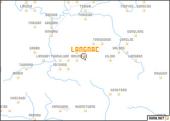
Làng Nác (Hà Bắc, Vietnam)Làng Nác is a town in the Hà Bắc region of Vietnam. An overview map of the region around Làng Nác is displayed below.
regional and 3d topo map of Làng Nác, Vietnam ::
Làng Nác airports ::
The nearest airport is HAN - Hanoi Noibai Intl, located 106.5 km west of Làng Nác.
Other airports nearby include NNG - Nanning Wuxu (207.1 km north east), Nearby towns ::
An Vinh (1.7km west) //
Ðảng Thôn (2.5km north west) //
Na Khả (3.5km west) //
Làng Bồng (4.1km north east) //
An Nương (3.9km south west) //
Trại Ðèo Sôi (5.1km north east) //
Vi Loại (5.2km east) //
Chảo Thôn (5.2km east) //
Thanh Luận (5.2km west) //
Tư Trang (5.5km west) //
Hạ Long (7.2km east) //
Ninh Phu (8.9km north west) //
Dông Vông (9.0km south east) //
Ðao Bình (10.1km north west) //
Kênh Trạo (10.1km south east) //
[all distances 'as the bird flies' and approximate] 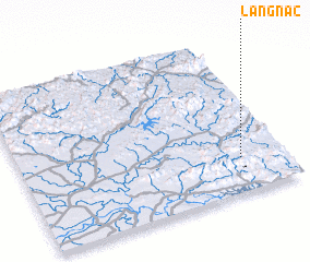 Places with similar names to Làng Nác, Vietnam ::
Disclaimer :: Information on this page comes without warranty of any kind |
||
|
Where is Làng Nác? Elevation and coordinates ::
Latitude (lat): 21°13'0"N Longitude (lon): 106°50'0"E
Elevation (approx.): 95m (map arrows pan, magnifying glasses zoom) |
||
|
Visiting Làng Nác? Hotel/Accommodation ::
Book a hotel in Làng Nác Travel Guide ::
Buy a travel guide for Vietnam rental cars ::
car rental offers GPS waypoint ::
download a GPX waypoint (PoI) of Làng Nác for your GPS receiver
|
||