|
search place name
|
||
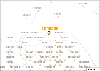
Làng Rau (Cao Bằng, Vietnam)Làng Rau is a town in the Cao Bằng region of Vietnam. An overview map of the region around Làng Rau is displayed below.
regional and 3d topo map of Làng Rau, Vietnam ::
Làng Rau airports ::
The nearest airport is HAN - Hanoi Noibai Intl, located 198.3 km south of Làng Rau.
Nearby towns ::
Nặm Ðin (1.9km south) //
Co Phày (1.9km south) //
Co Mười (1.7km west) //
Chang Vặc (2.5km south east) //
Lủng Măn (3.4km east) //
Kheo Khôm (3.9km south west) //
Thong Thou (3.9km south west) //
Làng Chuống (4.1km south east) //
Làng Po (4.1km south west) //
Sọc Năm (5.0km south east) //
Làng Mảo (5.6km south) //
Làng Táy (5.6km south) //
Lung Di (5.6km south) //
Năm Sấn (5.1km west) //
Dong Co (5.4km east) //
Làng Rại (6.5km south east) //
Ca Ria (6.3km south east) //
Nặm Giát (7.4km south) //
Cáy Tắc (6.8km west) //
Bó Sop (7.1km west) //
Xiaorui (7.6km north) //
Làng Rì (8.2km south east) //
Tàm Pống (8.2km south west) //
Nam Nhung (7.8km south west) //
Làng Bẩng (9.0km south west) //
Cảng Sốt (8.8km south east) //
Tâm Ðan (10.1km south west) //
Lingguang (10.5km north west) //
[all distances 'as the bird flies' and approximate]  Places with similar names to Làng Rau, Vietnam ::
Disclaimer :: Information on this page comes without warranty of any kind |
||
|
Where is Làng Rau? Elevation and coordinates ::
Latitude (lat): 22°59'0"N Longitude (lon): 106°9'0"E
Elevation (approx.): 823m (map arrows pan, magnifying glasses zoom) |
||
|
Visiting Làng Rau? Hotel/Accommodation ::
Book a hotel in Làng Rau Travel Guide ::
Buy a travel guide for Vietnam rental cars ::
car rental offers GPS waypoint ::
download a GPX waypoint (PoI) of Làng Rau for your GPS receiver
|
||