|
search place name
|
||
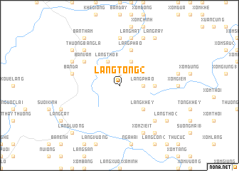
Làng Tong (2) (Vietnam)Làng Tong (2) is a town in Vietnam. An overview map of the region around Làng Tong (2) is displayed below.
regional and 3d topo map of Làng Tong (2), Vietnam ::
Làng Tong (2) airports ::
The nearest airport is HAN - Hanoi Noibai Intl, located 102.3 km east of Làng Tong (2).
Nearby towns ::
Làng Tong (1) (1.9km north) //
Làng Phao (3.5km east) //
Làng Tho (1) (4.1km north west) //
Làng Lom (4.1km north east) //
Làng Khey (5.1km south east) //
Làng Giem (5.2km east) //
Làng Phao (5.8km north) //
Bản Vầm (6.4km north west) //
Làng Co (7.4km north) //
Làng Lo (7.4km north) //
Bản Dạ (7.1km west) //
Làng Lót (7.6km north) //
Làng Mat (7.6km north) //
Làng Mo (7.6km south east) //
Thượng Bắng La (7.6km north west) //
Bản Bó (7.8km north west) //
Khê Ge (8.2km north east) //
Xóm Zieit (8.2km south east) //
Làng Queué (8.2km south east) //
Làng Ray (9.0km north east) //
Làng Biểu (8.9km north west) //
Bản Thẳm (9.0km north west) //
Làng Con (1) (9.0km south east) //
Làng Tho (2) (8.9km south east) //
Làng Lương (10.1km south west) //
[all distances 'as the bird flies' and approximate]  Places with similar names to Làng Tong (2), Vietnam :: Disclaimer :: Information on this page comes without warranty of any kind |
||
|
Where is Làng Tong (2)? Elevation and coordinates ::
Latitude (lat): 21°22'0"N Longitude (lon): 104°50'0"E
Elevation (approx.): 192m (map arrows pan, magnifying glasses zoom) |
||
|
Visiting Làng Tong (2)? Hotel/Accommodation ::
Book a hotel in Làng Tong (2) Travel Guide ::
Buy a travel guide for Vietnam rental cars ::
car rental offers GPS waypoint ::
download a GPX waypoint (PoI) of Làng Tong (2) for your GPS receiver
|
||