|
search place name
|
||
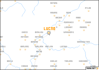
Lục Na (Quảng Ninh, Vietnam)Lục Na is a town in the Quảng Ninh region of Vietnam. An overview map of the region around Lục Na is displayed below.
regional and 3d topo map of Lục Na, Vietnam ::
Lục Na airports ::
The nearest airport is NNG - Nanning Wuxu, located 141.4 km north east of Lục Na.
Other airports nearby include HAN - Hanoi Noibai Intl (172.1 km west), Nearby towns ::
Pha Lạn (2.5km north east) //
Bình Liêu (3.4km west) //
Na Thắng (3.9km south west) //
Ðồng Long (5.1km north east) //
Pac Linh (5.6km south) //
Bác Buong (5.5km west) //
Khê Lanh (6.5km south west) //
Bản Cao (6.4km south west) //
Bắc Bin (6.5km north east) //
Dinh Duong (6.9km east) //
Long Way (7.1km east) //
Na Dang (7.6km north) //
Luc Nhu (7.6km south east) //
Hà Lâu (8.2km south west) //
Ngan Kheo (7.8km north east) //
Ðống Mồ (9.0km north east) //
Na Xa (10.1km north east) //
[all distances 'as the bird flies' and approximate] 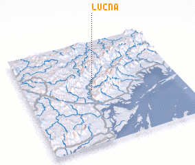 Places with similar names to Lục Na, Vietnam ::
Disclaimer :: Information on this page comes without warranty of any kind |
||
|
Where is Lục Na? Elevation and coordinates ::
Latitude (lat): 21°32'0"N Longitude (lon): 107°26'0"E
Elevation (approx.): 257m (map arrows pan, magnifying glasses zoom) |
||
|
Visiting Lục Na? Hotel/Accommodation ::
Book a hotel in Lục Na Travel Guide ::
Buy a travel guide for Vietnam rental cars ::
car rental offers GPS waypoint ::
download a GPX waypoint (PoI) of Lục Na for your GPS receiver
|
||