|
search place name
|
||
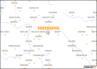
Mao Sao Ping (Vietnam)Mao Sao Ping is a town in Vietnam. An overview map of the region around Mao Sao Ping is displayed below.
regional and 3d topo map of Mao Sao Ping, Vietnam ::
Mao Sao Ping airports ::
The nearest airport is HAN - Hanoi Noibai Intl, located 195.9 km south east of Mao Sao Ping.
Nearby towns ::
Bo Dat (3.4km east) //
Tu Nhan (3.7km north) //
Ma Lou Tchoung (3.4km west) //
Tụ Nhân (3.9km south west) //
Cha Yin Tchai (5.6km north) //
Man Piao (5.5km west) //
Je Siao Ping (6.5km south west) //
Ta Ouan (7.4km south) //
Tsin Keou (7.6km north) //
Man Tie (7.1km west) //
Bản Koa (7.6km north west) //
Nam Ric (7.8km south west) //
Lan Quan (8.2km north west) //
Nam Tchong (10.1km south west) //
[all distances 'as the bird flies' and approximate]  Places with similar names to Mao Sao Ping, Vietnam ::
Disclaimer :: Information on this page comes without warranty of any kind |
||
|
Where is Mao Sao Ping? Elevation and coordinates ::
Latitude (lat): 22°42'0"N Longitude (lon): 104°46'0"E
Elevation (approx.): 1165m (map arrows pan, magnifying glasses zoom) |
||
|
Visiting Mao Sao Ping? Hotel/Accommodation ::
Book a hotel in Mao Sao Ping Travel Guide ::
Buy a travel guide for Vietnam rental cars ::
car rental offers GPS waypoint ::
download a GPX waypoint (PoI) of Mao Sao Ping for your GPS receiver
|
||