|
search place name
|
||
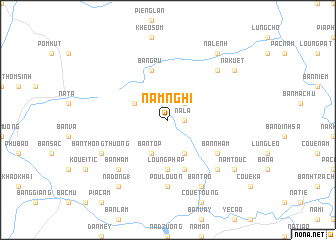
Nam Nghi (Bắc Thái, Vietnam)Nam Nghi is a town in the Bắc Thái region of Vietnam. An overview map of the region around Nam Nghi is displayed below.
regional and 3d topo map of Nam Nghi, Vietnam ::
Nam Nghi airports ::
The nearest airport is HAN - Hanoi Noibai Intl, located 148.4 km south of Nam Nghi.
Nearby towns ::
Na La (1.7km east) //
Kouai Cha (2.5km north east) //
Bản Ðuông (4.1km south east) //
Bản Top (4.1km south west) //
Côc Loung (3.9km north west) //
Loung Phap (5.6km south) //
Khau Coc (5.8km south) //
Bang Pu (5.8km north) //
Bản Nham (6.3km south east) //
Pou Louon (7.4km south) //
Beng Pouc (7.6km south east) //
Coue Sou (7.6km south east) //
Co Vai (7.6km north east) //
Bản Ham (7.6km south west) //
Bản Thong Thuong (7.8km south west) //
Bản Tao (8.2km south east) //
Kouei Tauo (8.2km south east) //
Nam Touc (8.8km south east) //
Na Kuet (8.8km north east) //
Nà Dong (1) (9.0km south west) //
Na Lênh (9.0km north east) //
[all distances 'as the bird flies' and approximate] 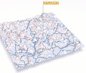 Places with similar names to Nam Nghi, Vietnam ::
Disclaimer :: Information on this page comes without warranty of any kind |
||
|
Where is Nam Nghi? Elevation and coordinates ::
Latitude (lat): 22°33'0"N Longitude (lon): 105°37'0"E
Elevation (approx.): 351m (map arrows pan, magnifying glasses zoom) |
||
|
Visiting Nam Nghi? Hotel/Accommodation ::
Book a hotel in Nam Nghi Travel Guide ::
Buy a travel guide for Vietnam rental cars ::
car rental offers GPS waypoint ::
download a GPX waypoint (PoI) of Nam Nghi for your GPS receiver
|
||