|
search place name
|
||
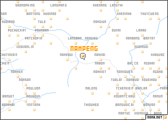
Nam Peng (Vietnam)Nam Peng is a town in Vietnam. An overview map of the region around Nam Peng is displayed below.
regional and 3d topo map of Nam Peng, Vietnam ::
Nam Peng airports ::
The nearest airport is HAN - Hanoi Noibai Intl, located 158.1 km east of Nam Peng.
Nearby towns ::
Nam Com (2.5km south west) //
Nâm Búng (3.4km west) //
Nam Poui (3.4km west) //
Gia Hội (3.4km east) //
Nậm Vai (3.4km east) //
Nà Bom (3.9km south east) //
Làng Ban (4.1km north west) //
Nâm Gièu (4.1km north east) //
Nâm Kiệt (5.1km south east) //
Bản Van (5.5km east) //
Na Léng (7.6km south) //
Làng Tinh (7.8km north west) //
Nặm Giùn (8.2km north east) //
Làng Báng (7.8km north east) //
Song Pan (9.0km south east) //
Ou Kai (8.8km north east) //
Khê Thếp (9.0km north east) //
Tưà Lai (8.9km south east) //
Na Lein (10.1km south east) //
Bản Chao (10.1km north west) //
[all distances 'as the bird flies' and approximate] 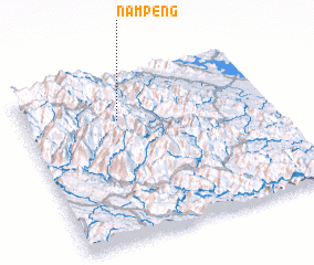 Places with similar names to Nam Peng, Vietnam ::
Disclaimer :: Information on this page comes without warranty of any kind |
||
|
Where is Nam Peng? Elevation and coordinates ::
Latitude (lat): 21°44'0"N Longitude (lon): 104°23'0"E
Elevation (approx.): 771m (map arrows pan, magnifying glasses zoom) |
||
|
Visiting Nam Peng? Hotel/Accommodation ::
Book a hotel in Nam Peng Travel Guide ::
Buy a travel guide for Vietnam rental cars ::
car rental offers GPS waypoint ::
download a GPX waypoint (PoI) of Nam Peng for your GPS receiver
|
||