|
search place name
|
||
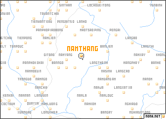
Nam Thang (Vietnam)Nam Thang is a town in Vietnam. An overview map of the region around Nam Thang is displayed below.
regional and 3d topo map of Nam Thang, Vietnam ::
Nam Thang airports ::
The nearest airport is HAN - Hanoi Noibai Intl, located 206.7 km south east of Nam Thang.
Nearby towns ::
Ly Tzeu Ping (2.5km south west) //
Nậm Yang (3.4km west) //
Nam Tong Sia Tcho (3.9km south west) //
Làng Thanh (3.9km south east) //
Ham Kai (3.9km south east) //
I Teau Wan (5.8km north) //
Bản Ngô (5.5km west) //
Mao Tsao Ping (5.8km north) //
Bản Lièn (5.5km east) //
Bản Tu (5.5km east) //
Na Sinh (6.3km south east) //
Lan Ho (7.4km north) //
Gi Tang (6.8km west) //
Nam Dậm Dảm (7.6km south east) //
Làng Hou (7.6km south east) //
Pè Ngai Tso (8.2km north west) //
Nam Liên (7.8km north west) //
Nậm Ja (8.2km south east) //
Pan Pho Piao Bong (8.8km north west) //
Pe Ngai (8.8km north east) //
[all distances 'as the bird flies' and approximate]  Places with similar names to Nam Thang, Vietnam ::
// Nāmthāng (IN)
// Nam Thuong (VN)
Disclaimer :: Information on this page comes without warranty of any kind |
||
|
Where is Nam Thang? Elevation and coordinates ::
Latitude (lat): 22°30'0"N Longitude (lon): 104°21'0"E
Elevation (approx.): 1005m (map arrows pan, magnifying glasses zoom) |
||
|
Visiting Nam Thang? Hotel/Accommodation ::
Book a hotel in Nam Thang Travel Guide ::
Buy a travel guide for Vietnam rental cars ::
car rental offers GPS waypoint ::
download a GPX waypoint (PoI) of Nam Thang for your GPS receiver
|
||