|
search place name
|
||
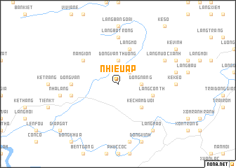
Nhiêu Ấp (Vietnam)Nhiêu Ấp is a town in Vietnam. An overview map of the region around Nhiêu Ấp is displayed below.
regional and 3d topo map of Nhiêu Ấp, Vietnam ::
Nhiêu Ấp airports ::
The nearest airport is SNO - Sakon Nakhon, located 239.0 km south west of Nhiêu Ấp.
Nearby towns ::
Kẻ Bục (2.5km north east) //
Ðóng Nang (3.5km east) //
Ðồng Vằn Thượng (3.7km north) //
Kẻ Chăm Dưới (5.1km south east) //
Làng Cơn Th (5.6km east) //
Kẻ Sui (5.6km east) //
Làng Mơ (5.8km north) //
Nam Giòn (6.4km north west) //
Làng Bã Trong (7.4km north) //
Dong Van (7.0km west) //
Ke On (7.2km west) //
Làng Nươc Xạnh (7.9km north east) //
Làng Rao (9.1km south east) //
[all distances 'as the bird flies' and approximate] 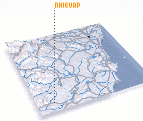 Places with similar names to Nhiêu Ấp, Vietnam ::
Disclaimer :: Information on this page comes without warranty of any kind |
||
|
Where is Nhiêu Ấp? Elevation and coordinates ::
Latitude (lat): 19°7'0"N Longitude (lon): 105°9'0"E
Elevation (approx.): 54m (map arrows pan, magnifying glasses zoom) |
||
|
Visiting Nhiêu Ấp? Hotel/Accommodation ::
Book a hotel in Nhiêu Ấp Travel Guide ::
Buy a travel guide for Vietnam rental cars ::
car rental offers GPS waypoint ::
download a GPX waypoint (PoI) of Nhiêu Ấp for your GPS receiver
|
||