|
search place name
|
||
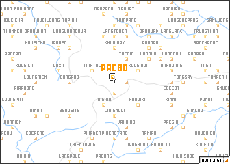
Pac Bó (Cao Bằng, Vietnam)Pac Bó is a town in the Cao Bằng region of Vietnam. An overview map of the region around Pac Bó is displayed below.
regional and 3d topo map of Pac Bó, Vietnam ::
Pac Bó airports ::
The nearest airport is HAN - Hanoi Noibai Intl, located 158.6 km south of Pac Bó.
Nearby towns ::
Nguyên Bình (1.7km east) //
Khuổi Cap Tau (1.9km south) //
Bản Nùng (2.5km north east) //
Tac Nio (4.1km north east) //
Nà Giảo (4.1km south west) //
Kouei Noi (3.9km north east) //
Nàm Pha Nưa (3.9km north west) //
Tĩnh Túc (3.9km north west) //
Khuổi Xả (5.0km south east) //
Bản Young (5.0km south east) //
Làng Mười (5.6km south) //
Khuổi Vảy (5.6km north) //
Làng Vài (6.3km north east) //
Dòng Poo (6.8km west) //
Làng Tchen (7.4km north) //
Nà Rỏng (7.6km south) //
Vài Khao (7.6km south) //
Cốc Càng (7.6km north) //
Khau Vài (7.6km north) //
Làng Oan (7.6km north east) //
Làng Ngoai (7.8km north east) //
Làng Quang Ðâu (7.8km north east) //
Làng Khinh (8.8km north east) //
Beau Site (8.8km south west) //
Kouei Hoa (8.8km north west) //
Bản Bua (1) (9.0km north east) //
Lung Luông Nua (10.1km north west) //
[all distances 'as the bird flies' and approximate]  Places with similar names to Pac Bó, Vietnam ::
Disclaimer :: Information on this page comes without warranty of any kind |
||
|
Where is Pac Bó? Elevation and coordinates ::
Latitude (lat): 22°39'0"N Longitude (lon): 105°55'0"E
Elevation (approx.): 512m (map arrows pan, magnifying glasses zoom) |
||
|
Visiting Pac Bó? Hotel/Accommodation ::
Book a hotel in Pac Bó Travel Guide ::
Buy a travel guide for Vietnam rental cars ::
car rental offers GPS waypoint ::
download a GPX waypoint (PoI) of Pac Bó for your GPS receiver
|
||