|
search place name
|
||
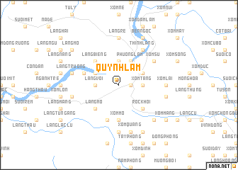
Quỳnh Lâm (Vietnam)Quỳnh Lâm is a town in Vietnam. An overview map of the region around Quỳnh Lâm is displayed below.
regional and 3d topo map of Quỳnh Lâm, Vietnam ::
Quỳnh Lâm airports ::
The nearest airport is HAN - Hanoi Noibai Intl, located 70.4 km north east of Quỳnh Lâm.
Nearby towns ::
Xóm Chang (1.7km east) //
Xóm Tang (3.5km east) //
Xóm Gioc Khoi (3.5km east) //
Làng Vach (3.7km north) //
Làng Voi (3.5km west) //
Hòa Bình (4.0km north east) //
Phương Lâm (3.9km north east) //
Phương Lâm (4.1km north east) //
Làng Tháu (3.9km north west) //
Róc Khơi (5.1km south east) //
Làng Mõ (5.1km south west) //
Làng Biêng (5.1km north west) //
Xóm Ma (5.6km south) //
Xóm Mõ (5.6km south) //
Bắc Phong (5.8km south) //
Làng Nưa (5.5km west) //
Xóm Giãi (5.8km south) //
Xóm Man (5.8km south) //
Thinh Làng (6.6km north east) //
Su Ngoi (6.4km north east) //
Xóm Su (6.4km north east) //
Làng Tiêng (7.4km south) //
Xóm Lai (6.9km east) //
Làng Re (7.4km north) //
Xóm Quang (7.6km south) //
Quê Thiều (7.2km east) //
Lương Thân (7.2km west) //
Làng Trai (7.2km west) //
Lang Trương (7.2km west) //
[all distances 'as the bird flies' and approximate]  Places with similar names to Quỳnh Lâm, Vietnam ::
Disclaimer :: Information on this page comes without warranty of any kind |
||
|
Where is Quỳnh Lâm? Elevation and coordinates ::
Latitude (lat): 20°47'0"N Longitude (lon): 105°19'0"E
Elevation (approx.): 165m (map arrows pan, magnifying glasses zoom) |
||
|
Visiting Quỳnh Lâm? Hotel/Accommodation ::
Book a hotel in Quỳnh Lâm Travel Guide ::
Buy a travel guide for Vietnam rental cars ::
car rental offers GPS waypoint ::
download a GPX waypoint (PoI) of Quỳnh Lâm for your GPS receiver
|
||