|
search place name
|
||
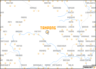
Tam Pong (Bắc Thái, Vietnam)Tam Pong is a town in the Bắc Thái region of Vietnam. An overview map of the region around Tam Pong is displayed below.
regional and 3d topo map of Tam Pong, Vietnam ::
Tam Pong airports ::
The nearest airport is HAN - Hanoi Noibai Intl, located 112.1 km south of Tam Pong.
Nearby towns ::
Ang Ta (2.5km south west) //
Piet Pit (3.4km west) //
Vang Bo (4.1km south west) //
Bản Khang (4.1km south west) //
Na Ma (5.1km east) //
Pieng Leng (5.1km west) //
Bản Dan (5.6km south) //
Vang Hang (5.5km east) //
Pieng Poung (6.9km west) //
Lung Nie (7.1km east) //
Na Vang (7.6km south) //
Loung Tiang (7.1km east) //
Bản Pien (7.1km east) //
Kouei Ioum (7.6km south east) //
Bản Bung (8.2km south east) //
Ham Toc (8.2km south west) //
Na Pen (10.1km south east) //
[all distances 'as the bird flies' and approximate] 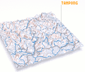 Places with similar names to Tam Pong, Vietnam ::
Disclaimer :: Information on this page comes without warranty of any kind |
||
|
Where is Tam Pong? Elevation and coordinates ::
Latitude (lat): 22°14'0"N Longitude (lon): 105°46'0"E
Elevation (approx.): 640m (map arrows pan, magnifying glasses zoom) |
||
|
Visiting Tam Pong? Hotel/Accommodation ::
Book a hotel in Tam Pong Travel Guide ::
Buy a travel guide for Vietnam rental cars ::
car rental offers GPS waypoint ::
download a GPX waypoint (PoI) of Tam Pong for your GPS receiver
|
||