|
search place name
|
||
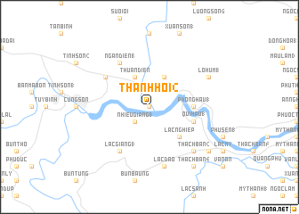
Thanh Hội (2) (Vietnam)Thanh Hội (2) is a town in Vietnam. An overview map of the region around Thanh Hội (2) is displayed below.
regional and 3d topo map of Thanh Hội (2), Vietnam ::
Thanh Hội (2) airports ::
The nearest airport is NHA - Nhatrang, located 90.5 km south of Thanh Hội (2).
Nearby towns ::
Thạnh Hội (3) (0.0km north) //
Nhiễu Giang (1) (2.6km south west) //
Thuân Diền (4.1km north west) //
Buôn Suối Câu (4.1km north east) //
Ngân Ðiền (3) (4.1km north west) //
Lạc Nghiệp (5.2km south east) //
Phong Hậu (1) (5.4km east) //
Qui Hậu (1) (5.7km east) //
Ngân Ðiền (1) (6.6km north west) //
Lạc Giang (1) (6.6km south west) //
Buôn Suối Bac (6.6km north west) //
Lang Phú Hữu (6.6km north west) //
Lạc Ðạo (7.6km south) //
Thạch Bàn (2) (7.8km south east) //
Lạc Ðiên (2) (7.8km south east) //
Lỗ Hùm (1) (8.1km north east) //
Thạch Bàn (4) (9.2km south east) //
Thạch Bàn (1) (9.1km south east) //
[all distances 'as the bird flies' and approximate] 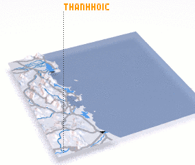 Places with similar names to Thanh Hội (2), Vietnam ::
Disclaimer :: Information on this page comes without warranty of any kind |
||
|
Where is Thanh Hội (2)? Elevation and coordinates ::
Latitude (lat): 13°2'0"N Longitude (lon): 109°3'0"E
Elevation (approx.): 29m (map arrows pan, magnifying glasses zoom) |
||
|
Visiting Thanh Hội (2)? Hotel/Accommodation ::
Book a hotel in Thanh Hội (2) Travel Guide ::
Buy a travel guide for Vietnam rental cars ::
car rental offers GPS waypoint ::
download a GPX waypoint (PoI) of Thanh Hội (2) for your GPS receiver
|
||