|
search place name
|
||
Thiện Nguyên (Vietnam)Thiện Nguyên is a town in Vietnam. An overview map of the region around Thiện Nguyên is displayed below.
regional and 3d topo map of Thiện Nguyên, Vietnam ::

Thiện Nguyên airports ::
The nearest airport is HAN - Hanoi Noibai Intl, located 131.0 km north west of Thiện Nguyên.
Nearby towns ::
Chi Thien (1.7km west) //
Tập Thiện (3.9km south west) //
Nam Thành (4.1km north west) //
Lộc Trung (5.6km north) //
Thanh Hương (1) (5.5km west) //
Thiện Tường (5.8km north) //
Trung Thành (5.8km north) //
Viên Ngoai Khu (5.8km north) //
Doãn Thượng (2) (6.6km north west) //
Bằng Viên (6.4km south east) //
Ðại Ðồng (7.4km north) //
Giáo Phòng (7.0km west) //
Hữu Vi (7.6km north) //
Thanh Chầu (1) (7.6km north) //
Ðịnh Hải (7.2km west) //
Ản Tư Ha (7.6km north west) //
Nội Lãng (7.6km north west) //
Xuân Thiện (7.9km south west) //
Dương Liễu (8.9km north west) //
[all distances 'as the bird flies' and approximate] 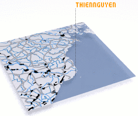 Places with similar names to Thiện Nguyên, Vietnam ::
// Thái Nguyên (VN)
// Thị Nguyên (VN)
Disclaimer :: Information on this page comes without warranty of any kind |
||
|
Where is Thiện Nguyên? Elevation and coordinates ::
Latitude (lat): 20°16'0"N Longitude (lon): 106°33'0"E
(map arrows pan, magnifying glasses zoom) |
||
|
Visiting Thiện Nguyên? Hotel/Accommodation ::
Book a hotel in Thiện Nguyên Travel Guide ::
Buy a travel guide for Vietnam rental cars ::
car rental offers GPS waypoint ::
download a GPX waypoint (PoI) of Thiện Nguyên for your GPS receiver
|
||