|
search place name
|
||
Thôn Thủy Yên (Vietnam)Thôn Thủy Yên is a town in Vietnam. An overview map of the region around Thôn Thủy Yên is displayed below.
regional and 3d topo map of Thôn Thủy Yên, Vietnam ::

Thôn Thủy Yên airports ::
The nearest airport is DAD - Danang Intl, located 36.5 km south east of Thôn Thủy Yên.
Nearby towns ::
Thôn Thủy Yên (2.6km north east) //
Thôn Phú Cường (3.7km north) //
Thôn Phú Xuyên (3.7km north) //
Thôn Cao Ðôi Ấp (4.0km north west) //
Thôn Thủy Dương (5.3km east) //
Thôn Tân An (5.6km north) //
Thôn Phước An (5.7km east) //
Phú Lộc (5.7km west) //
Thôn Ðông Lưu (5.7km west) //
Thôn Phước Hung (5.8km north) //
Thôn Phước Lộc (6.5km north east) //
Thôn Cảnh Dương (7.7km north east) //
Bạch Mã (9.0km south west) //
[all distances 'as the bird flies' and approximate] 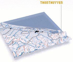 Places with similar names to Thôn Thủy Yên, Vietnam ::
// Thanthania (BD)
// Thanh Thần (VN)
// Thạnh Thới An (VN)
// Thịnh Thôn (VN)
// Thinh Thon (VN)
// Thôn Thái An (VN)
// Thôn Thành Hòa (VN)
// Thôn Thành Ý (VN)
// Thôn Thủy Yên (VN)
// Thuận Thanh (VN)
Disclaimer :: Information on this page comes without warranty of any kind |
||
|
Where is Thôn Thủy Yên? Elevation and coordinates ::
Latitude (lat): 16°15'0"N Longitude (lon): 107°56'0"E
Elevation (approx.): 8m (map arrows pan, magnifying glasses zoom) |
||
|
Visiting Thôn Thủy Yên? Hotel/Accommodation ::
Book a hotel in Thôn Thủy Yên Travel Guide ::
Buy a travel guide for Vietnam rental cars ::
car rental offers GPS waypoint ::
download a GPX waypoint (PoI) of Thôn Thủy Yên for your GPS receiver
|
||