|
search place name
|
||
Trapéang Ro Say (Tây Ninh, Vietnam)Trapéang Ro Say is a town in the Tây Ninh region of Vietnam. An overview map of the region around Trapéang Ro Say is displayed below.
regional and 3d topo map of Trapéang Ro Say, Vietnam ::

Trapéang Ro Say airports ::
The nearest airport is SGN - Ho Chi Minh City Tansonnhat Intl, located 82.8 km south east of Trapéang Ro Say.
Other airports nearby include PNH - Phnom-penh Phnom Penh Intl (131.9 km west), Nearby towns ::
Trapéang Kor (2) (1.9km north) //
Trapéang Kor (1) (3.7km north) //
Xóm Bào Năng (4.1km south east) //
Xóm Mắt Cát (4.1km south east) //
Xóm Cây Chỏ (4.1km north east) //
Tra Sim (5.5km east) //
Xóm Bố (5.6km north) //
Xóm Mía (5.8km north) //
Xóm Rong Nhương (6.6km south east) //
Phumĭ Sângkôm Méanchey (6.6km south west) //
Phumĭ Léab (7.5km west) //
Phumĭ Prey Ta Ei (7.6km south) //
Bến Cồ Nổi (7.8km north east) //
Phum Skir (7.8km north west) //
Tô Hạp (8.3km north east) //
Rô Bân (9.2km north west) //
[all distances 'as the bird flies' and approximate] 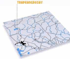 Places with similar names to Trapéang Ro Say, Vietnam :: Disclaimer :: Information on this page comes without warranty of any kind |
||
|
Where is Trapéang Ro Say? Elevation and coordinates ::
Latitude (lat): 11°12'0"N Longitude (lon): 106°0'0"E
Elevation (approx.): 7m (map arrows pan, magnifying glasses zoom) |
||
|
Visiting Trapéang Ro Say? Hotel/Accommodation ::
Book a hotel in Trapéang Ro Say Travel Guide ::
Buy a travel guide for Vietnam rental cars ::
car rental offers GPS waypoint ::
download a GPX waypoint (PoI) of Trapéang Ro Say for your GPS receiver
|
||