|
search place name
|
||
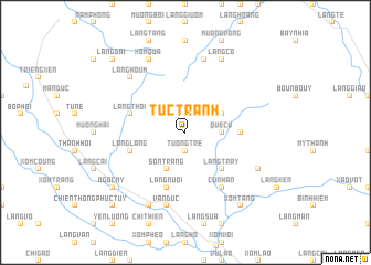
Tức Tranh (Vietnam)Tức Tranh is a town in Vietnam. An overview map of the region around Tức Tranh is displayed below.
regional and 3d topo map of Tức Tranh, Vietnam ::
Tức Tranh airports ::
The nearest airport is HAN - Hanoi Noibai Intl, located 83.1 km north east of Tức Tranh.
Nearby towns ::
Vui Thương (1.9km north) //
Tương Tre (1.9km south) //
Què Cù (3.5km east) //
Làng Khem (3.9km north east) //
Quí Hòa (3.9km north east) //
Sơn Tráng (4.1km south west) //
Làng Tray (5.1km south east) //
Làng Cay (5.1km south east) //
Làng Lạng (5.2km east) //
Làng Thôi (5.5km west) //
Làng Lang (5.5km west) //
Làng Nuôi (5.8km south) //
Cư Nhân (6.6km south east) //
Ba Róng (7.6km north) //
Văn Ðức (7.6km south) //
Làng Houm (7.6km north west) //
Làng Cô (8.2km north east) //
Thach An (8.2km north west) //
Xóm Qua (8.2km north west) //
Làng Ðôi Vong (7.9km south east) //
Làng Oc (8.2km south west) //
Thân Thượng (8.2km south west) //
Ngọc Mỹ (8.9km south west) //
Xóm Tang (9.1km south east) //
Làng Dái (10.2km north west) //
Phúc Tuy (10.2km south west) //
Làng Vua (10.2km south west) //
[all distances 'as the bird flies' and approximate]  Places with similar names to Tức Tranh, Vietnam ::
Disclaimer :: Information on this page comes without warranty of any kind |
||
|
Where is Tức Tranh? Elevation and coordinates ::
Latitude (lat): 20°34'0"N Longitude (lon): 105°25'0"E
Elevation (approx.): 337m (map arrows pan, magnifying glasses zoom) |
||
|
Visiting Tức Tranh? Hotel/Accommodation ::
Book a hotel in Tức Tranh Travel Guide ::
Buy a travel guide for Vietnam rental cars ::
car rental offers GPS waypoint ::
download a GPX waypoint (PoI) of Tức Tranh for your GPS receiver
|
||