|
search place name
|
||
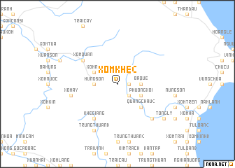
Xóm Khe (2) (Vietnam)Xóm Khe (2) is a town in Vietnam. An overview map of the region around Xóm Khe (2) is displayed below.
regional and 3d topo map of Xóm Khe (2), Vietnam ::
Xóm Khe (2) airports ::
The nearest airport is ZVK - Savannakhet, located 225.1 km south west of Xóm Khe (2).
Other airports nearby include DAD - Danang Intl (287.1 km south east), Nearby towns ::
Ðồng Rừng (1.8km east) //
Thủy Vực (2.6km north east) //
Vưc Trơn (2.6km south east) //
Hung Sơn (3.5km west) //
Ba Que (3.5km east) //
Xóm Roi (4.0km north west) //
Liêu Sơn (4.0km south east) //
Phường Xỏi (4.0km south east) //
Dất Ðỏ (5.1km south east) //
Quảng Châu (2) (5.1km south east) //
Khê Giang (6.6km south west) //
Xóm Quán (6.5km north west) //
Xóm Ấy (7.3km west) //
Hòa Lạc (7.7km south east) //
Trung Thuần (1) (8.2km south west) //
Tông Lý (9.0km south east) //
[all distances 'as the bird flies' and approximate] 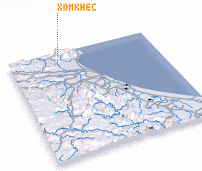
Disclaimer :: Information on this page comes without warranty of any kind |
||
|
Where is Xóm Khe (2)? Elevation and coordinates ::
Latitude (lat): 17°55'0"N Longitude (lon): 106°20'0"E
Elevation (approx.): 21m (map arrows pan, magnifying glasses zoom) |
||
|
Visiting Xóm Khe (2)? Hotel/Accommodation ::
Book a hotel in Xóm Khe (2) Travel Guide ::
Buy a travel guide for Vietnam rental cars ::
car rental offers GPS waypoint ::
download a GPX waypoint (PoI) of Xóm Khe (2) for your GPS receiver
|
||