|
search place name
|
||
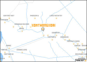
Xóm Thông Xoài (Long An, Vietnam)Xóm Thông Xoài is a town in the Long An region of Vietnam. An overview map of the region around Xóm Thông Xoài is displayed below.
regional and 3d topo map of Xóm Thông Xoài, Vietnam ::
Xóm Thông Xoài airports ::
The nearest airport is SGN - Ho Chi Minh City Tansonnhat Intl, located 53.4 km east of Xóm Thông Xoài.
Other airports nearby include PNH - Phnom-penh Phnom Penh Intl (174.7 km north west), Nearby towns ::
Tuyên Nhơn (1.9km south) //
Xóm Ngã Cậy (2.6km south east) //
Thủy Ðông (5.2km south east) //
Xóm Bà Xây (5.8km east) //
Ấp Phong Hòa (5.8km west) //
Ấp Vịnh Sao (5.8km west) //
Phong Phú (6.6km north west) //
Long Thành Tây (7.8km north east) //
[all distances 'as the bird flies' and approximate] 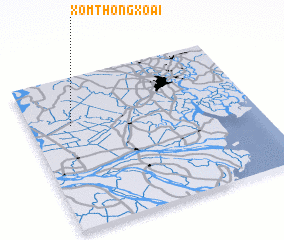 Places with similar names to Xóm Thông Xoài, Vietnam :: Disclaimer :: Information on this page comes without warranty of any kind |
||
|
Where is Xóm Thông Xoài? Elevation and coordinates ::
Latitude (lat): 10°41'0"N Longitude (lon): 106°11'0"E
(map arrows pan, magnifying glasses zoom) |
||
|
Visiting Xóm Thông Xoài? Hotel/Accommodation ::
Book a hotel in Xóm Thông Xoài Travel Guide ::
Buy a travel guide for Vietnam rental cars ::
car rental offers GPS waypoint ::
download a GPX waypoint (PoI) of Xóm Thông Xoài for your GPS receiver
|
||