|
search place name
|
||
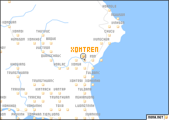
Xóm Trên (Vietnam)Xóm Trên is a town in Vietnam. An overview map of the region around Xóm Trên is displayed below.
regional and 3d topo map of Xóm Trên, Vietnam ::
Xóm Trên airports ::
The nearest airport is ZVK - Savannakhet, located 230.8 km south west of Xóm Trên.
Other airports nearby include DAD - Danang Intl (277.2 km south east), Nearby towns ::
Xóm Dưới (0.0km north) //
Phú Lộc (0.0km north) //
Di Lôc (1.9km south) //
Xóm Hạ (1.9km south) //
Tùng Chât (1.8km west) //
Quảng Châu (1) (1.8km west) //
Bắc Hà (1.8km east) //
Phước Kiều (1.8km east) //
Ròn (1.8km east) //
Hòa Bình (2.6km south west) //
Xóm Ðá (2.6km south west) //
Cảnh Dương Xã (2.6km south east) //
Kiêm Long (2.6km north west) //
Nùng Sơn (2.6km north west) //
Thôn Thay (3.7km south) //
Nam Lanh (3.5km east) //
Tông Lý (4.0km south west) //
Tú Loan (2) (4.1km south east) //
Vụng Chùa (5.1km north east) //
Xóm Cát (5.6km south) //
Hòa Lạc (5.6km west) //
Xóm Trại (5.8km south) //
Phương Ðình (5.8km south) //
Xóm Kinh (1) (5.8km south) //
Chúc Mac (6.5km north east) //
Tú Loan (1) (7.4km south) //
Dất Ðỏ (7.1km west) //
Quảng Châu (2) (7.1km west) //
Liêu Sơn (7.3km west) //
[all distances 'as the bird flies' and approximate] 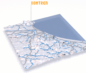 Places with similar names to Xóm Trên, Vietnam ::
// Šmitrani (BA)
// Šmitrani (BA)
// Šmitrani (BA)
// Sambo Dorni (NG)
// Xóm Tran (VN)
// Xóm Tranh (VN)
// Xóm Tranh (VN)
// Xóm Trà Nô (VN)
// Xóm Trên (VN)
// Xóm Trên (VN)
Disclaimer :: Information on this page comes without warranty of any kind |
||
|
Where is Xóm Trên? Elevation and coordinates ::
Latitude (lat): 17°53'0"N Longitude (lon): 106°26'0"E
Elevation (approx.): 4m (map arrows pan, magnifying glasses zoom) |
||
|
Visiting Xóm Trên? Hotel/Accommodation ::
Book a hotel in Xóm Trên Travel Guide ::
Buy a travel guide for Vietnam rental cars ::
car rental offers GPS waypoint ::
download a GPX waypoint (PoI) of Xóm Trên for your GPS receiver
|
||