|
search place name
|
||
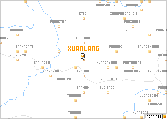
Xuận Lang (Vietnam)Xuận Lang is a town in Vietnam. An overview map of the region around Xuận Lang is displayed below.
regional and 3d topo map of Xuận Lang, Vietnam ::
Xuận Lang airports ::
The nearest airport is NHA - Nhatrang, located 113.9 km south of Xuận Lang.
Nearby towns ::
Làng Danh Phước (0.0km north) //
Xuận Hãm Hãn (2.6km south west) //
Tân Hôi (1) (3.7km south) //
Tổng Bình (3.7km north) //
Xuận Cây Gia (1) (5.7km east) //
Lang Ba Bang (5.7km west) //
Xuận Tra Ke (6.6km south west) //
Tân Hội (3) (7.4km south) //
Phú Thuận (1) (7.5km east) //
Phú Hội (2) (7.5km east) //
Xuận Hố Diêt (2) (7.8km south east) //
Ban Ma Hanh (8.1km south west) //
Suối Bac (2) (9.2km south east) //
Phước Tân (9.2km north west) //
[all distances 'as the bird flies' and approximate] 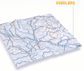 Places with similar names to Xuận Lang, Vietnam ::
// Sanlong (MM)
// Senlung (MM)
// Sinhlaung (MM)
// Sinlaung (MM)
// Sinlu-aing (MM)
// Sinluaing (MM)
// Sinlung Ga (MM)
// Son Laing (MM)
// Snelling (US)
// Senaling (MY)
Disclaimer :: Information on this page comes without warranty of any kind |
||
|
Where is Xuận Lang? Elevation and coordinates ::
Latitude (lat): 13°14'0"N Longitude (lon): 108°58'0"E
Elevation (approx.): 316m (map arrows pan, magnifying glasses zoom) |
||
|
Visiting Xuận Lang? Hotel/Accommodation ::
Book a hotel in Xuận Lang Travel Guide ::
Buy a travel guide for Vietnam rental cars ::
car rental offers GPS waypoint ::
download a GPX waypoint (PoI) of Xuận Lang for your GPS receiver
|
||