|
search place name
|
||
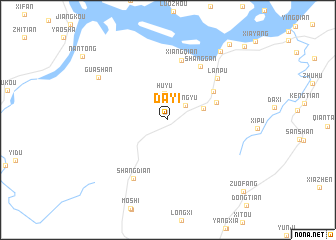
Dayi (Fujian, China)Dayi is a town in the Fujian region of China. An overview map of the region around Dayi is displayed below.
regional and 3d topo map of Dayi, China ::
Dayi airports ::
The nearest airport is FOC - Fuzhou Changle, located 33.4 km east of Dayi.
Other airports nearby include MZW - Matsu Beigan (77.1 km north east), KNH - Chinmen Shang Yi (188.0 km south west), XMN - Xiamen Gaoqi (191.1 km south west), TPE - Taipei Chiang Kai Shek Intl (210.1 km south east), Nearby towns ::
Hongyu (2.4km north east) //
Huyu (3.0km north) //
Fuzhu (3.8km east) //
Qingpu (5.3km east) //
Qingkou (5.6km north east) //
Xiangqian (6.8km north) //
Shanggan (6.8km north east) //
Lanpu (6.8km north east) //
Shangdian (7.4km south west) //
Guashan (8.5km north west) //
Zhenfeng (9.3km north east) //
Minjiang (10.5km north east) //
Zuofang (11.0km south east) //
Huangshi (11.2km north east) //
[all distances 'as the bird flies' and approximate] 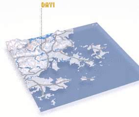 Places with similar names to Dayi, China ::
Disclaimer :: Information on this page comes without warranty of any kind |
||
|
Where is Dayi? Elevation and coordinates ::
Latitude (lat): 25°52'25"N Longitude (lon): 119°20'12"E
Elevation (approx.): 40m (map arrows pan, magnifying glasses zoom) |
||
|
Visiting Dayi? Hotel/Accommodation ::
Book a hotel in Dayi Travel Guide ::
Buy a travel guide for China rental cars ::
car rental offers GPS waypoint ::
download a GPX waypoint (PoI) of Dayi for your GPS receiver
|
||