|
search place name
|
||
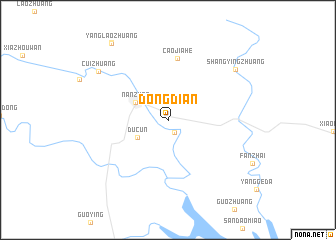
Dongdian (Henan, China)Dongdian is a town in the Henan region of China. An overview map of the region around Dongdian is displayed below.
regional and 3d topo map of Dongdian, China ::
Dongdian airports ::
The nearest airport is CGO - Zhengzhou Xinzheng, located 172.8 km north east of Dongdian.
Nearby towns ::
Shizhuang (1.5km south east) //
Ducun (3.5km south west) //
Nanzhao (3.6km north west) //
Caojiahe (6.9km north) //
Shangyingzhuang (8.5km north east) //
Cuizhuang (8.5km north west) //
Yanglaozhuang (10.1km north west) //
Liushan (10.2km north west) //
[all distances 'as the bird flies' and approximate] 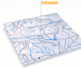 Places with similar names to Dongdian, China ::
// Dinaguitan (PH)
// Taungdan (MM)
// Taungdin (MM)
// Taungdun (MM)
// Taunggadon (MM)
// Taungtin (MM)
// Taungtin (MM)
// Dingden (DE)
// Tinguatón (ES)
// Tangoden (BF)
Disclaimer :: Information on this page comes without warranty of any kind |
||
|
Where is Dongdian? Elevation and coordinates ::
Latitude (lat): 33°28'19"N Longitude (lon): 112°27'26"E
Elevation (approx.): 190m (map arrows pan, magnifying glasses zoom) |
||
|
Visiting Dongdian? Hotel/Accommodation ::
Book a hotel in Dongdian Travel Guide ::
Buy a travel guide for China rental cars ::
car rental offers GPS waypoint ::
download a GPX waypoint (PoI) of Dongdian for your GPS receiver
|
||