|
search place name
|
||
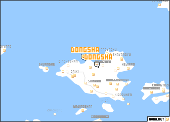
Dongsha (Zhejiang, China)Dongsha is a town in the Zhejiang region of China. An overview map of the region around Dongsha is displayed below.
regional and 3d topo map of Dongsha, China ::
Dongsha airports ::
The nearest airport is NGB - Ninbo Lishe, located 84.8 km south west of Dongsha.
Other airports nearby include SHA - Shanghai Hongqiao Intl (124.6 km north west), HGH - Hangzhou Xiaoshan (164.4 km west), Nearby towns ::
Qiaotoujian (1.7km south east) //
Dongsha (3.0km south east) //
Qianchang (3.4km south east) //
Qingheshan (3.4km west) //
Daixi (3.7km south west) //
Fujia (3.6km east) //
Nizhizhen (3.6km east) //
Yaoxingpu (4.2km south west) //
Kaowangchang (4.2km south west) //
Liujiaʼao (4.9km south) //
Jiangyaohu (4.5km east) //
Hou'an (4.8km south west) //
Guandidian (4.9km east) //
Shimaʼao (5.6km south) //
Daizhong (6.1km south east) //
Tangdun (6.7km south) //
Caojia (6.1km east) //
Daidong (6.5km east) //
Moxin (7.0km south east) //
Miaoyan (7.0km east) //
Shayangyu (7.0km east) //
Shuanghe (7.4km west) //
Xiaogaoting (8.3km south east) //
Wangguanniʼao (8.0km south east) //
Daishan (8.6km south east) //
Gaoting (9.5km south east) //
Xiaopumen (11.1km south east) //
[all distances 'as the bird flies' and approximate] 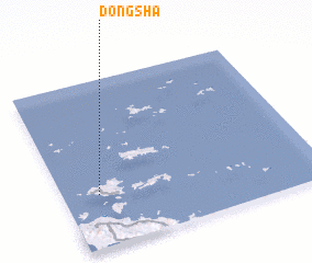 Places with similar names to Dongsha, China ::
Disclaimer :: Information on this page comes without warranty of any kind |
||
|
Where is Dongsha? Elevation and coordinates ::
Latitude (lat): 30°18'49"N Longitude (lon): 122°8'24"E
Elevation (approx.): 5m (map arrows pan, magnifying glasses zoom) |
||
|
Visiting Dongsha? Hotel/Accommodation ::
Book a hotel in Dongsha Travel Guide ::
Buy a travel guide for China rental cars ::
car rental offers GPS waypoint ::
download a GPX waypoint (PoI) of Dongsha for your GPS receiver
|
||