|
search place name
|
||
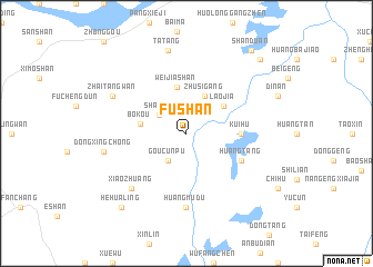
Fushan (Anhui, China)Fushan is a town in the Anhui region of China. An overview map of the region around Fushan is displayed below.
regional and 3d topo map of Fushan, China ::
Fushan airports ::
The nearest airport is NKG - Nanjing Lukou, located 81.7 km north east of Fushan.
Other airports nearby include HFE - Hefei Luogang (121.9 km north west), Nearby towns ::
Goucunpu (3.2km south west) //
Shanhu (3.0km north west) //
Zhusigang (4.0km north east) //
Shiguizhen (4.0km north east) //
Laojia (4.2km north east) //
Bokou (4.1km west) //
Weijiashan (4.7km north) //
Kuihu (4.8km east) //
Huangtang (5.5km south east) //
Huangmudu (7.4km south) //
Congludun (7.4km south) //
Fengxiangdun (7.3km south west) //
Xiaozhuang (7.3km south west) //
Eqiao (7.3km north west) //
Zhaitangwan (7.3km north west) //
Dongxingchong (7.4km west) //
Tatang (8.5km north) //
Hehualing (9.3km south west) //
Qiancao (9.8km north east) //
Shanduan (10.0km north east) //
[all distances 'as the bird flies' and approximate] 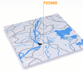 Places with similar names to Fushan, China ::
Disclaimer :: Information on this page comes without warranty of any kind |
||
|
Where is Fushan? Elevation and coordinates ::
Latitude (lat): 31°9'0"N Longitude (lon): 118°21'0"E
Elevation (approx.): 10m (map arrows pan, magnifying glasses zoom) |
||
|
Visiting Fushan? Hotel/Accommodation ::
Book a hotel in Fushan Travel Guide ::
Buy a travel guide for China rental cars ::
car rental offers GPS waypoint ::
download a GPX waypoint (PoI) of Fushan for your GPS receiver
|
||