|
search place name
|
||
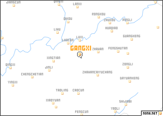
Gangxi (Jiangxi, China)Gangxi is a town in the Jiangxi region of China. An overview map of the region around Gangxi is displayed below.
regional and 3d topo map of Gangxi, China ::
Gangxi airports ::
The nearest airport is KHN - Nanchang Changbei Intl, located 179.5 km south west of Gangxi.
Nearby towns ::
Luxi (4.1km north) //
Zhawan (3.6km east) //
Luocun (4.3km north west) //
Zhawancai Yuchang (5.2km south east) //
Xingtian (5.6km west) //
Jinli (7.1km south west) //
Liwu (7.5km north west) //
Caocun (8.2km south) //
Fengshutan (7.5km east) //
Qikou (8.7km north) //
Taoling (9.1km south west) //
Huaqiao (8.7km north east) //
Zhukou (9.8km north east) //
[all distances 'as the bird flies' and approximate] 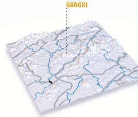 Places with similar names to Gangxi, China ::
// Kangcuas (PH)
// Kinkakasa (CG)
// Kinkakasa (CG)
// Kinnkakassa (CG)
// Kinnkakassa (CG)
// Kinnkakassa (CG)
// Kinnkakassa (CG)
// Cương Xa (VN)
// Quang Xá (VN)
// Quang Xá (VN)
Disclaimer :: Information on this page comes without warranty of any kind |
||
|
Where is Gangxi? Elevation and coordinates ::
Latitude (lat): 29°39'41"N Longitude (lon): 117°30'28"E
Elevation (approx.): 149m (map arrows pan, magnifying glasses zoom) |
||
|
Visiting Gangxi? Hotel/Accommodation ::
Book a hotel in Gangxi Travel Guide ::
Buy a travel guide for China rental cars ::
car rental offers GPS waypoint ::
download a GPX waypoint (PoI) of Gangxi for your GPS receiver
|
||