|
search place name
|
||
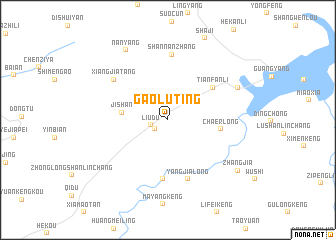
Gaoluting (Anhui, China)Gaoluting is a town in the Anhui region of China. An overview map of the region around Gaoluting is displayed below.
regional and 3d topo map of Gaoluting, China ::
Gaoluting airports ::
The nearest airport is HFE - Hefei Luogang, located 171.7 km north of Gaoluting.
Other airports nearby include NKG - Nanjing Lukou (185.3 km north east), KHN - Nanchang Changbei Intl (248.6 km south west), Nearby towns ::
Yongxi (1.6km south west) //
Liudu (1.8km west) //
Jishan (4.5km west) //
Cha'erlong (5.3km east) //
Tianfanli (5.6km north east) //
Qingxi (6.6km south) //
Yangjialong (6.9km south) //
Shannanzhang (7.3km north) //
Xiangjiatang (6.9km north west) //
Huangtuling (7.6km north east) //
Nanyang (8.8km north west) //
Zhangjia (8.8km south east) //
[all distances 'as the bird flies' and approximate] 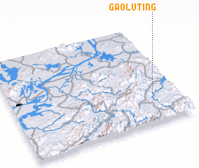 Places with similar names to Gaoluting, China ::
Disclaimer :: Information on this page comes without warranty of any kind |
||
|
Where is Gaoluting? Elevation and coordinates ::
Latitude (lat): 30°18'34"N Longitude (lon): 117°51'47"E
Elevation (approx.): 144m (map arrows pan, magnifying glasses zoom) |
||
|
Visiting Gaoluting? Hotel/Accommodation ::
Book a hotel in Gaoluting Travel Guide ::
Buy a travel guide for China rental cars ::
car rental offers GPS waypoint ::
download a GPX waypoint (PoI) of Gaoluting for your GPS receiver
|
||